Scott Lehman at one of my favorite petroglyph panels.
(Click on images to view larger)
When I first visited Cedar Mesa in the 1980s, Grand Gulch was obscure, with word-of-mouth descriptions of arduous bushwacking and secret ruins. Since then, guidebooks have been published, books written, and the Bears Ears National Monument created, diminished, and finally restored, hopefully forever. A growing number of people hike regularly in the Gulch and its tributaries, and it seems that everyone has a secret undisclosed discovery, enticing the rest of us to keep looking. Despite growing popularity, it remains one of my favorite places; no one will ever peer into every hidden alcove or look behind every exfoliated boulder to find the last undiscovered treasure, and even without its cultural heritage, Grand Gulch is stunning.
In March of 2021, I spent a week with Ellen and our friends, Scott and Bay, hiking from Collins Spring to Kane Gulch, about 38 miles. We’d all walked much of this section and many of its side canyons before but in pieces on many trips over many years, so it was fun to traverse it in one hike.
While the walking was easy (we planned short days to leave time for ruins and rock art), the drought presented challenges. Water in much of the canyon had disappeared, and hikers, us included, planned our days and camps around what little water could be found, some barely drinkable even with filtering. I recently wrote about climate migrations in the Southwest, partly stimulated by this experience of traversing the canyon in a dry year. Until about 700 years ago, it supported a thriving Ancestral Puebloan community. The gist of that post was that drought destabilized their society, leading to abandonment.
While on this hike, I realized that drought need not be long-term to drive people out. After a few years without good monsoon rains or winter snow, most of the water was gone. How long could permanent residents of Cedar Mesa live and farm without regular rain? A few years? A decade? How much water could they store from ephemeral summer showers or winter snow? Are there enough obscure springs to sustain a substantial population through several dry years? I don’t know the answers to these questions, but when we were in the canyon in March, there was barely water to support a few dozen backpackers on their vacations, passing through the canyon for only a few days.
These are a few pictures from our trip. Except for some of the well-known sites, I don't specify locations.
Ellen and Bay (not Bei, our daughter!) enjoying pictographs in a Rincon north of the junction of Grand Gulch and Collins Spring.
The Bannister Ruin. We camped near here on the first night. Bannister spring was dry (we carried water from the trailhead) but I scrambled to a pothole above the canyon floor that was filled with good water.
An arrowhead found in the wash and returned to it after being admired. I recommend Craig Child's book, "Finders, Keepers" for those of you interested in respecting archeological finds. Handprints.
Routefinding is not too tough when you are following a major canyon, but keeping track of side canyons requires some attention.
A small man (me), and woman (Ellen) sit below the Big Man Panel north of Polly's Canyon.
More handprints. Bay recreates the moment.
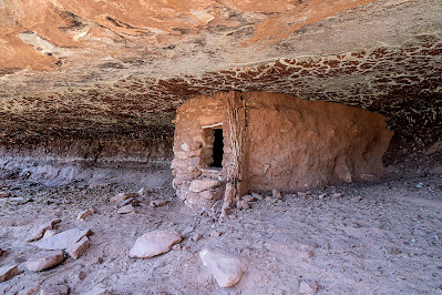
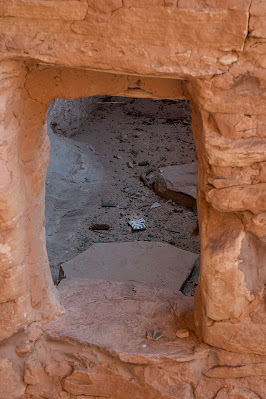
An intact granary tucked beneath a reticulated roof.
The bird panel. I carried my lightweight backpacking camera without a very long lens, and these were high above the canyon floor, but you can zoom in to see better. The pictographs are exquisitely detailed.
Ellen and Bay scrambling to see a ruin and rock art in a side canyon.
Bay (left) and Ellen enjoying rock art.
The breech birth panel.
Our camp on a ledge above Coyote Canyon. The spring in the canyon bottom produced good water.
A potsherd inside a ruin.
A wall tucked behind a fallen boulder, with pictographs lined up under the arch behind it.
Bay admiring a petroglyph panel at the mouth of Todie Canyon.
After the hike. Left to right: Bay Roberts, Scott Lehman, Ellen Axtmann, and me.
Water info: Grand Gulch was very dry after a multi-year drought and the failure of the monsoon the previous summer. We found water in a pothole (ephemeral) at our first camp
near the Banister ruin on a slickrock shelf that required scrambling to access. There was water in
lower Collins Canyon and for short way up Grand Gulch from the confluence, and again in
pools in the main Gulch just downcanyon from Polly's. Water was available
a short way up Green Canyon and farther along
in Green Mask Canyon below the well-known rock art site. The
Coyote Canyon spring was running. Farther up, we filtered nasty water from
a pool under a pouroff down canyon from the mouth of Todie Canyon. We were told that there was water
up Todie in the North Fork, but we used our filtered water instead. From there, we walked out to Kane Gulch.
Don't rely on the BLM office in Monticello, though they may have some information. If the Kane Gulch Ranger Station is open, it’s a more reliable source of information. Of course, there can be much more or much less (!) water depending on the year.
Another much more detailed blog post on this hike going in the other direction is at this
link and there are many other detailed accounts online if you search for them.


Ken, It is so great reading your post and seeing that you are well and happy. Your life continues to be deeply aligned with what's important to you. All the best to you. Meg Waldron
ReplyDeleteThanks Meg! All the best to you too!
DeleteKen, with drought conditions in the southwest caused by climate change, I wonder when it will no longer be possible to backpack in Grand Gulch? SO grateful we could explore there!
ReplyDeleteHi Bay, So true. Even last fall I’ll bet it was tough. Looking forward to our trip next week!
DeleteFascinating text and photos, thanks Ken!
ReplyDeleteThanks Darrow. I'm looking forward to hiking with you in the Rincons this month!
DeleteGreat blog Ken, hope to catch you next year when there is no work.
ReplyDeleteThanks Jack. Likewise! You’re almost to the finish line. Let’s do some trips!
DeleteGreat summary of the hike and beautiful pictures. Thanks for sharing and peaking my interest in this area. Hope you, Ellen and Bei are all well!
ReplyDeleteThanks!
DeleteThanks Ken for providing this blog providing a thoughtful glimpse of this magical place--a sacred place of which I have no experience nor, at this age, ever will. You vicariously extended my range of life experiences.
ReplyDeleteBill
Thanks, Bill!
DeleteGreat Share, Ken!!! Some & saw but most I didn't on a solo Grand Gulch trip around '86. You documented some amazing panels!!!
ReplyDeleteThanks Dan!
DeleteHi Ken, Beautiful photos that bring back great memories of my time as a seasonal ranger in Natural Bridges in 1984! I had the opportunity to do many hikes in Grand Gulch and surrounding canyons. Unfortunately I also witnessed evidence of grave robbing that occurred in between two visits to the same site, just a few weeks apart. Scandalous that the BLM knew the likely suspects but could only arrest if they were caught in the act.
ReplyDeleteWe are looking forward to spending some time in the US this April-July now that the borders are finally reopening. Would be great to see you. Cheers mate - Elise
Thanks Elise. I'm jealous that you got to spend so much time there back then. My visits were superficial. The site robbing is a tragedy. You've probably read "Finders Keepers" but if not, you'd probably find it interesting. We're just home from a week on the Comb Ridge--nice and warm for this time of year! I hope you guys are doing well!
DeleteEnjoy going back & looking thru your photographs. I wii never go there, but have an interest in the subject. The etching of breech birth reminded me of pictograph i saw on lage rocks on farm in Southern Mo,near Missippi river. The figure had several large eggs
ReplyDeleteIn a half circle below it, supposedly representing a multiple birth. GINNY
Hi Ginny, Thanks for looking. That’s really interesting about the Missouri pictographs. I’d love to see them. Take care.
DeleteI dont have photograph. The archaologist that I knew asked if I had photographs. I dont know if he planned to publish them. I have regretted for years I didnt get copies back & dont know if i could find negatives. Ill try to ck into it. He & his wife have been travelling around the world. It seems they have been gone a year
DeleteLost first text. I dont have copy of the pictograph. The archaeologist I was with called & asked me if I tool pictures and i sent them to him. I never got them back.Regretted that for many years. Hes been on a trip around the world,for a year it seems. Dont know if hes returned but i will try to contact him.
ReplyDeleteHave you settled in to a new home. are u experiencing terribly hot weather there. Humidity makes it worse here. Be safe.
Thanks for looking into it. We’re just moving in today. It’s in the 70s, so no complaints!
DeleteHave just come back to look at your wonderful photos. At my age I shall never see them in person but I have had the greatest interest for a very long time. Even seeing your photos is an excitement for me. Have only gone on locals digs after
ReplyDeletetaking a few courses in my 40s. Lo e the Boobie Hatching phrase. Remember the term growing up. When I was a little older,remember Helen referring to the tv as
The Boob Tube. She was one of the most interesting persons in my life.