Showing posts with label archaeology. Show all posts

Thursday, January 9, 2025

Visiting Paquime in Chihuahua, Mexico

The ruin of Paquime near Nuevo Casas Grandes in Chihuahua, Mexico.
(Click images to view larger)

In December 2001, not long before we became parents, Ellen and I drove from Laramie, Wyoming to El Potrero Chico, just north of Monterrey, Mexico to rock climb, and then we continued across northern Mexico to the city of Chihuahua before reentering the U.S. south of Marfa, Texas. At that time, travel in the Mexican borderlands felt safe, and we enjoyed exploring small towns and the big city of Chihuahua. I still remember a misty and chilly sunrise in Parral (a town along the way) with views to the southwest into intriguing mountains that are now a no-go due to cartel activity. 

Today, the U.S. State Department advises Americans to “reconsider” travel to Chihuahua due to crime and kidnapping, including the danger of violent gang activity, but there are relatively safe corridors and destinations, so last March (2024) a group of us organized a trip with Luis Benavadiz, a guide from The Pink Store in Puerto Palomas, a Mexican border town south of Silver City, to Nuevo Casas Grandes, near the famous ruins of Paquime. We’d wanted to see Paquime for years because of its importance in Southwestern archaeology, and although we probably could have driven ourselves, Luis made the trip less stressful and showed us places along the way that we would have missed on our own. And we breezed past Federale checkpoints that might have been less friendly to a bunch of gringos. 

Paquime was an important political center that peaked after Chaco Canyon and other northern settlements were abandoned in the 12th century A.D. At the height of its importance, it may have been home to as many as 10,000 people, but by 1450 it was mostly abandoned. Paquime had a substantial number of enclosures for raising Scarlet macaws which were ritualistically important throughout Ancestral Puebloan societies far to the north. The Edge of the Cedars Museum in Blanding, Utah, for example, has a beautiful macaw feather sash in its collections that was found in the Abajo Mountains of SE Utah. Paquime may have had political influence over a large area, though there is debate about its extent. 
 
Luiz stuck to a choreographed 2-day plan on our trip, effortlessly herding us around. On the first day, we visited Mata Ortiz, south of Nuevo Casas Grandes to see (and hopefully buy) the pottery that they are famous for thanks to a nearby clay deposit. I was more interested in the town than the pots, so I slipped out of potters’ houses to photograph buildings, but enough of our group bought pottery to make the visit worthwhile for the potters and, I imagine, Luiz. We also visited the once opulent but now run-down Hacienda de San Diego, a sprawling ranch off the beaten track once owned by Luis Terrazas, the richest man in Chihuahua. In its heyday, it housed many workers, but most of the buildings are now in disrepair. 
 
The second day was mostly spent at the sprawling Paquime ruin, our main objective, but we also visited a neatly trimmed Mormon settlement with tidy houses and fenced lawns. Mormons escaping the ban on polygamy in the 1890s established colonies in Chihuahua, and Luiz said that many of the residents are now successful businesspeople who commute regularly between Salt Lake City and Nuevo Casas Grandes. By late on the second day, we returned to Puerto Palomas, walked across the border, and retrieved our cars from the dusty parking lot beside a Dollar General to return to Silver City.

There are many other temptations in Chihuahua, including the massive Copper Canyon, home of the Tarahumara people, known for their running prowess, and intriguing smaller but less visited ruins, not to mention the endless obscure mountain ranges hiding who-knows-what. Although unimportant compared to the impact of cartels on the lives of many Mexicans, it's heartbreaking to live so close to Mexico and not feel safe enough to explore there. But prudence suggests waiting and hoping that borderland tourism gets safer while we’re still spry enough to wander.

Peach trees (Mormon?) in an orchard along the highway. There are substantial Mormon settlements in Chihuahua originally established by fundamentalists escaping the U.S. ban on polygamy in the 1890s. Mitt Romney has family ties here.

An old store in Mata Ortiz, south of Nuevo Casas Grandes. This town is famous for its exquisite pottery, but I was more interested in walking the streets to look at buildings.

Another building in Mata Ortiz.

A screen door in Mata Ortiz.

Bottle caps above a doorway in Mata Ortiz. Why?

Another Mata Ortiz house.

Abandoned workers' quarters at the Hacienda de San Diego.

A vaquero's rope hangs outside an enclosed corral.

One of the workers' quarters.

An old tree beside workers' quarters at the Hacienda.

Graffiti in an Hacienda doorway.

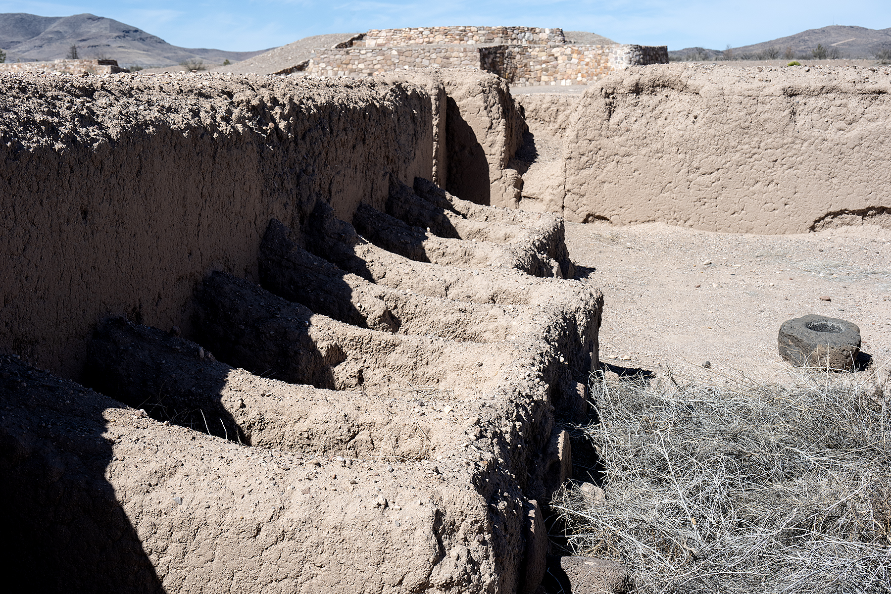
Paquime after excavation and restoration. The site covers a large area near the Casas Grandes river. Many Ancestral Puebloans may have migrated here after the collapse of the Chaco polity.

Luiz Benavadiz, our guide for the trip, at Paquime. He was funny, friendly, and knowledgeable. Luiz runs trips out of The Pink Store in Puerto Palomas.

Scarlet macaw breeding pens (but see comment below on macaws) at Paquime. Evidence suggests that these macaws did not lead happy lives. Macaw feathers are found over a vast area of Mesoamerica and the U.S. Southwest suggesting ritual importance.


Monday, May 20, 2024

Lower Gila Box Canyon, New Mexico


Cliffs in one of the side canyons of the Lower Gila Box in New Mexico.
(Click images to view larger)

In 1983, the late M.H. Salmon and his dog, Rojo, hiked from the source of the Gila River in the Aldo Leopold Wilderness to where it emerges from the mountains near Gila, NM. There, he picked up his cat and canoed through three box canyons (the Upper, Middle, and Lower) in New Mexico and another (
the Gila Box) in Arizona, ending his trip before the river succumbed to agricultural diversion on its way to join the Colorado near Yuma, Arizona. He called his animal companions “the crew” and sometimes left them alone by the river to forage while he wandered into nearby towns to socialize and lament the loss of an unnamed romantic partner. His book, Gila Descending, A Southwestern Journey, is a classic. Salmon was a lifelong advocate for the Gila River, and today a bill named for him and reintroduced by New Mexico Senators Martin Heinrich and Ben Ray Luhan could permanently protect over 400 miles of it.


Box canyons in southern New Mexico don’t dead end like the ones in old Westerns where, depending on who was doing the chasing, good or bad guys rode in but didn’t ride out. Instead, they are cliff-lined gorges where the river meanders from side to side making walking almost impossible. Side canyons provide access here and there, and boating is possible when the water is high, but the canyon interiors remain remote and seldom visited.


Miraculously, the Gila is one of the few substantial undammed rivers in the southwest (except for irrigation diversion), rising and falling with runoff and the seasons. Despite many attempts to dam it over the years, the river has remained free-flowing thanks to the efforts of conservation groups, New Mexico Senators, and devoted individuals like Salmon.


Today, the Lower Box of the Gila is a Wilderness Study Area (WSA), meaning that it has characteristics that make it eligible for Wilderness designation by Congress. WSAs are managed to preserve these qualities until Congress makes a decision. 


Just before entering the Lower Box on his journey, Salmon wrote:

People rule the natural world today and everywhere you look we’ve made a hash of it. A rare gem like the pristine Gila only serves to balance otherwise zealous commercial interests. In juxtaposition, a free-flowing stream may be the most civilized item within our realm. More than birds can benefit from association with a wild river.

In southern New Mexico, winter is the time for desert exploring, and we made a half dozen or more trips to explore Lower Box and the surrounding area during our first cool season since moving to Silver City in 2023. I’m grateful to have such a diverse and archaeologically rich place so close to home. 


On publication of the fourth edition of his book in 2006, Salmon ended a new introduction by urging us to keep up the good fight:

More than 20 years ago, Rojo, the tomcat, and I saw the whole 220 miles of river in one trip. I thought at the time: All said, there's not a better place anywhere in the West. In spite of boosters, boomers, politicians, and certain government agencies, that's still true today. The Gila River is the last flow in New Mexico that can still teach us what a natural river should be. Improbably, it still flows free. Enjoy it. Don't let them take it away. 


Ellen in the Chihuahuan Desert preparing for a hike near the Lower Box.


The Lower Box Canyon in December with a few lingering yellow cottonwood trees. 


Hiking in a side canyon last December with Larry Scritchfield and Jane Addis (2023).

Trees and cliffs deep inside the Lower Box.

A shockingly green rock layer in one of the side canyons of the Lower Box.

Ellen in a green slot canyon.

Ellen with T Rolloff in another side canyon.


The Lower Box has been used by humans for thousands of years. Bedrock mortars like these are common.

As are petroglyphs. These are near the mouth of one of the many side canyons.

Steve Buskirk exploring in the hills above the Box Canyon.

Ellen and her brother, Terry, in a side canyon. Oddly, we've had more visitors during the winter in Southern New Mexico than we ever did when we lived in Laramie.

Petroglyphs high above the river.

Bedrock mortars at a rock outcrop a few miles north of the Lower Box.

The Jaguar Panel.

Ocotillo and poppies near the rim of the Lower Box.

An ocotillo under a New Mexican sky near the rim of the Box. March 2024.

Ellen, Bay Roberts, and Beth Buskirk hiking towards the Lower Box, March 2024.


Tuesday, January 2, 2024

Exploring Fable Valley


Fable Valley in fall color. Archaeological sites occupy both sides of the canyon, the sagebrush flats, and even the tops of sandstone towers like the one in the distant background.
(Click images to view larger)

Fable Valley cuts into the Dark Canyon Plateau joining Gypsum Canyon before emptying into the Colorado River deep in Cataract Canyon. In 1869, during his descent of the Green and Colorado, the one-armed John Wesley Powell hiked into Gypsum from the river, nearly getting caught in a flash flood and turning back before reaching the mouth of Fable Valley. 


Our trip last October was less dramatic than Powell’s, but it required driving 40 miles on occasionally narrow and exposed dirt roads to reach the trailhead. I was grateful for both arms as I gripped the steering wheel of our van, hoping not to encounter oncoming traffic (we didn’t). We spent four days in the valley and two full days searching for archaeology, wandering up- and down-canyon from camp, scrambling up boulder-studded slopes to ruins or rock art sites and never traveling more than a couple of miles as the crow flies because there was so much to see.


Had Powell made it into Fable over 150 years ago, he would have found mostly undisturbed remnants of a substantial Ancestral Puebloan community spread from one end of the canyon to the other, with Mesa Verde style cliff dwellings and granaries in high alcoves and multi-room settlements in the sagebrush below. In the interval between 1869 and 2023, most of the ruins were scavenged, though pot sherds and lithics remain. Gordon Baldwin superficially surveyed the valley in 1949, describing 24 sites but noting even then that “…from the number of ruins that show signs of digging, it is evident that pot hunters, including a number of unauthorized expeditions, have been active in certain sections for some time.”


Even during Baldwin’s trip, a few remnants of settlements stood where today there is only sagebrush. We searched actively for a “ground ruin” below the largest cliff dwelling a mile or so upcanyon from our camp and found only pot sherds and a few low walls. Baldwin observed that the same site “seemingly contained more than 200 rooms and probably stood more than two stories in height,” while also describing a seven-foot-high corner wall that “may represent all that remains of the rectangular towers noted by [Dr. Byron] Cummings.” Cummings visited the valley in 1909, only 40 years before Baldwin when the ruins were less disturbed. When we visited, even the corner wall was gone. Despite that, finding what remains was exciting and fun.


Baldwin published his findings in the Southwestern Journal of Anthropology but admitted that “Due to the hurried nature of the trip and other phases of the recreational aspects of the region that had also to be investigated [emphasis mine] comparatively little time could actually be devoted to archaeological exploration.” Despite those weasel words, his paper contributed to our then sparse knowledge of the region. 


Like Baldwin, we were a little hurried, spending only four days car-to-car since some of our group of six had to return to work and others had plans to “investigate other phases of the recreational aspects of the region,” as Baldwin so eloquently put it. 


A structure in an alcove down-canyon from our camp, accessed by scrambling from above and traversing across a ledge.

The group at the structure in the previous picture. Left to right: Ellen, Bay, Jane, Steve, and Larry.

A handprint panel with stylized hands painted with concentric lines.

We saw many pot sherds but no snakes, probably because the fall nights were getting cold.

Bay (left) and Ellen scouting for sites.

A circular wall on top of the tower visible in the photo at the top of this post. Accessing it required an easy 4th-class scramble up a ledgy weakness. 

Bay and Jane descending from the tower.

Pictographs near our camp. All of the figures are connected.

Fable Valley itself is appealing even without the lure of archaeology. In October, cottonwood trees were approaching peak color.

On our second full day we explored up-valley from our camp, hiking towards the sun through backlit  grasses and shrubs.

Indian rice grass and other grasses and shrubs in the morning sun.

Pictographs and handprints.

A granary looks out over Fable Valley from an alcove in a side canyon.

Larry entering the most prominent ruin we visited, high above the valley floor. This ruin has been preserved to some extent. Replaced roof logs were cut with saws rather than fire, and portions of walls were rebuilt. 

Ellen, Larry, and Bay approaching a ruin. Steve had hiked out earlier that day to return to work. 

Jane and Larry clawing their way out of a gully in the valley on the hike out. The deeply incised creek and its side drainages were hard to cross. I suspect that when the valley was occupied, they were shallower.

Back at the trailhead and ready to "investigate other phases of recreational aspects of the region." 
L to R: Bay, Larry, Jane, Ellen.


References

Adkison, Ron. 1998. Hiking Grand Staircase-Escalante & the Glen Canyon Region. A Falcon Guide.

Baldwin, Gordon C. 1949. Archaeological survey in Southeastern Utah. Southwestern Journal of Anthropology 5(4):393-404.

Cummings, Byron. 1910. The ancient inhabitants of the San Juan Valley. Bulletin, University of Utah 3(3) Part 2.

Midwest Archaeological Center National Park Service, Lincoln, Nebraska. 1978. Archaeological resources of Canyonlands, Capitol Reef, and Arches National Parks and Natural Bridges National Monument, Southeastern Utah. Vol. 1. 

Road Trip Ryan (website)