Showing posts with label badlands. Show all posts

Wednesday, May 14, 2025

Bisti Badlands, New Mexico


Ellen on a walk in the Bisti Badlands.
(Click images to view larger)


The term "badlands" sounds harsh, but barren eroding landscapes have been called that for centuries. Here in New Mexico, craggy lava flows, though not erosional, are called malpaises (bad country or bad places). French trappers called badlands les mauvaises terre a traverser, meaning “bad lands to traverse,” perhaps the origin of the English term. The trappers were probably influenced by the Lakota (according to Wikipedia), who called these places mako sica (bad or eroded land). Regardless of language, it’s not hard to understand why landscapes nearly devoid of vegetation and animal life might have been considered “bad” if you needed to find dinner or get across them on a hot day.

But it’s all relative. If I were a French trapper, or Lakota, or a Spanish conquistador, or even a modern farmer (or an antelope), I might find the term appropriate, but as a wanderer camping in empty places with my camera, badlands doesn’t ring true. I’ve had some pretty good times in some pretty bad lands. 

Badlands National Park, by virtue of being a park, is probably the most recognized badlands site in the U.S., but it’s one among many equally spectacular places. If you saw the movie, Nomadland, you’ll remember that Fern, played by Francis McDormand, spent time working at a campground near the South Dakota Park and found herself calmed by its beauty, though she eventually moved on, as nomads do. Ellen and I visited colorful badlands in Oregon in the John Day Fossil Beds National Monument on our first road trip after retiring in 2021 before moving on ourselves to float the John Day River in our packrafts.

Ellen in the Painted Hills at the John Day Fossil Beds, Oregon.

Wyoming’s Red Desert, where I spent lots of time before moving south, has national park quality badlands, though wilderness protection might be more appropriate for these remote places. The Honeycomb Buttes in the northern Red Desert and the Adobe Town and Skull Rims farther south are spectacular and little-visited, at least compared to the South Dakota badlands. I once camped on the Adobe Town rim with Ellen and Bei and discovered a family of coyotes with pups denned in an eroded hole just below our camp. They seemed undisturbed by us, maybe remote enough not to have been harassed by humans. On a hot day during another Adobe Town trip, I found a soapstone medicine pipe in the cool shade of a rock tower. 

A wash below the Skull rim in Wyoming.

New Mexico, where I live now, has more than its share of badlands. I’m just beginning to learn about them and have only recently begun to explore. Some of the most well-known, are the Bisti (pronounced Bist-eye, not Bist-eee) Badlands south of Farmington. The Bisti are part of the Bisti/De-Na-Zin Wilderness Area surrounded by Navajo, BLM, and private lands. In recent years they’ve gotten increasing attention, probably because their weird erosional formations attract photographers, but when we were there in April (2025), despite a surprising number of campers in the main parking area, we mostly had the place to ourselves as we wandered among hoodoos, “cracked eggs,” and petrified wood. 

A downside of the term “badlands” is that some think that they are literally bad, with little value except perhaps for oil and gas drilling or other destructive activities. This, of course, is not the case. Badlands are beautiful and unique, deserving of preservation.

Early morning in the Bisti Badlands.

Bisti Badlands.

Bisti Badlands erosion.

There are a few hardy shrubs in the badlands.

Formations known as the stone wings in the Bisti Badlands.

The nearby Angel Peak area is also vast and eroded.


Saturday, January 28, 2023

Death Valley Backpacking: Cottonwood - Marble Canyon Loop

View of Death Valley badlands from Zabriskie Point.
(Click images to view larger)

Death Valley is famously hot, dry, and barren, but cold temperatures, flooding, and bushwacking posed challenges during a short visit in January 2023. The park is nothing if not diverse, with elevations ranging from 292 feet below sea level in Badwater Basin to over 11,000’ at the summit of Telescope Peak, so it's not surprising that conditions don't always match the cliches. When I met Larry Scritchfield for a little mid-winter backpacking (and to escape the relentless Wyoming cold), high temperatures averaged around 60 in the basins, way warmer than the surrounding mountains where we hiked, many blanketed with snow. 


Salt Creek on the floor of Death Valley. The white stuff is salt, not snow. (Photo from Dec. 2021 when Ellen and I passed through on our way home from a climbing trip to the Alabama Hills west of Death Valley)

A pan in the Mesquite Dunes east of Stovepipe Wells. (Dec. 2021)

Gower Gulch from Zabriskie Point. Zabriskie Point is a popular roadside overlook, named for a borax magnate. (Dec. 2021)


We’d also hoped to get a taste of Death Valley canyoneering, known for rappels off carefully constructed rock piles (sketchy??), but our canyon partner, Don Reyes, who lives near Lake Tahoe, was digging his renters out of serial Sierra snowstorms and had to bail at the last minute. Canyoneering is collaborative--more fun and safer with three than two, so we postponed those plans.


Larry not canyoneering (still sketchy) in Stretched Pebble Canyon during a day hike. (Jan. 2023)


Larry and I rendezvoused at Stovepipe Wells, just below sea level, where a friendly hotel (showers for $5!) and restaurant on one side of Hwy. 190 face a campground and store on the other. The campground, mostly empty in January, is a gravel parking lot with carbonite posts marking sites, devoid even of picnic tables. We parked on one edge of the lot, giving us access to the empty desert for late-night peeing. Not far to the east, the Mesquite Dunes spawned plumes of dust that thankfully blew away from the campground on frequent windy days. To the west, the Cottonwood Mountains, part of the Panamint Range, where we planned to hike, dominated the skyline, their highest peaks dusted with snow. 


The Stovepipe Wells "campground." It's really just gravel parking places though there are some tent sites that have tables. The Cottonwood Mountains, where we eventually hiked, are in the background. (Jan. 2023)


Flash floods during the August (2022) monsoon washed out many roads in the park, including access to popular tourist spots (Scotty’s Castle, the Racetrack, etc.), and a smaller rain event just before we arrived turned the road to the 28-mile Cottonwood-Marble Canyon loop, our main backpacking objective, into a quagmire. An apologetic ranger at the small Stovepipe Wells station where we stopped to collect our free permit delivered the bad news, squashing our plan to start the 4-day hike that morning. Instead, we regrouped and headed for Indian Pass in the Funeral Mountains on the eastern edge of the park, an overnight out-and-back that included a 4-mile slog up an alluvial fan (fanyoneering?), while we waited for the Cottonwood Canyon road to dry out. 


Camp in the Indian Pass canyon in the Funeral Mts. (Jan. 2023)

Recent rains left plenty of water in potholes in upper Indian Pass Canyon. (Jan. 2023)


Later in the week, after the overnight and two day-hikes, we finally started the loop, which climbs gently up Cottonwood Canyon, then north up a swale to eventually cross a saddle before descending steeply into Deadhorse Canyon which drains into Marble Canyon, itself descending through spectacular narrows back to the trailhead. Along the way we enjoyed impossibly complex geology, petroglyphs (spaceships??), wild horses, freeze-dried lasagna, and perfect but freezing campsites. 


I seldom move much before finishing my morning coffee, and pre-caffeine I don’t even like to be asked about what I might do later in a day. But in one of the hottest places on the planet, it was so cold (and windy) at our first two camps that Larry and I crammed our gear into our packs at dawn and walked until we could find sunshine and a little warmth before brewing freeze-dried Via “coffee” packets and eating breakfast. Probably in the low to mid-20s at night, desert cold always feels colder than mountain cold. I hiked those mornings in the winter clothes (hat, gloves, long underwear, puffy) that I wear Nordic skiing at 9000’ in sub-arctic Laramie, Wyoming and still didn't feel quite warm.


Lower Cottonwood Canyon on our the first day of our loop hike. I ended up shooting iPhone photos on this trip because the sensor on my backpacking camera was unexpectedly dirty. (This and all Cottonwood-Marble photos are from Jan. 2023)

Our first camp in Cottonwood Canyon.

Larry enjoying a wee nip of tequila at our first camp in Cottonwood Canyon.

Larry in upper Marble Canyon.

Approaching one of the narrows in Marble Canyon.

Zebra-striped rock in Marble Canyon.

Petroglyphs in Marble Canyon.

Narrows in Marble Canyon.

Marble Canyon looking towards the narrows in the preceding photo.

Marble Canyon.

Boulder, Marble Canyon.

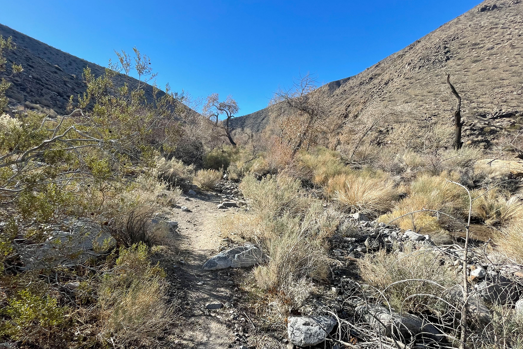
Another ironic challenge on the hike was vegetation. We joked about bushwacking on the Indian Pass hike whenever we passed close to an infrequent creosote bush. How naïve we were! In Cottonwood Canyon and to a lesser degree in Dead Horse Canyon, what little vegetation there was packed itself into the V-shaped drainages where the few springs provided enough water for trees, choking the canyon with an impassable tangle of downed cottonwood limbs, fallen trunks, and impenetrable shrubs, some thorny, forcing us up onto steep, loose, sidehills above the drainage, sometimes exposed enough to drive us reluctantly back down to bushwack hopelessly until we could find another escape. Short distances near these “oases” took longer to traverse than miles of open desert.

Approaching a section of bushwacking that is WAY worse than it looks. 

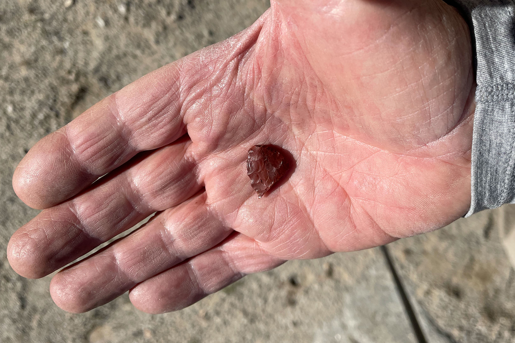
The only flake I found on this trip was this broken point that I happened upon while side-hilling above a spring to avoid bushwacking, so perhaps we were not the first to grovel around the springs.


Death Valley is a vast park, too hot most of the year for much activity, but a refuge in winter. From salt flats, dunes, and badlands to mountains harboring ancient but threatened bristlecone pines there’s enormous diversity. And despite the harshness, humans have left their mark with old mines, ghost towns, and remnants of a once thriving borax industry (20-mule trains!). It attracts desert rats and misfits as well as cyclists, outdoor adventurers, and retirees. I find myself there once in a while, and though I often wonder if I’ll return, each trip leaves me curious about just one more thing that I’d like to check out. 


View from an abandoned building at Death Valley Junction, just outside the Park.


Monday, January 18, 2016

Uinta County, Wyoming

An abandoned gas station along I-80 near Lyman, in Uinta County, Wyoming.
(Click images to view larger)

Interstate 80 between Rock Springs and Salt Lake City divides Wyoming’s Uinta County into two landscapes. North of the highway are dry rolling shrublands interrupted by a few small towns, while to the south, complicated badlands erode into rivers, including the Bear and the Black’s Fork, that flow out of the Uinta Mountains of Utah. I’ve spent little time exploring this part of Wyoming, but last fall Ed Sherline and I headed there for a weekend in hopes of answering a call for a photo of Uinta County as part of the art to be installed in the remodeled gymnasium at the University of Wyoming. We spent most of our time south of I-80 in the badlands, but also enjoyed exploring towns along and north of the interstate, which used to be the iconic Lincoln Highway.

Here are a few pictures from the weekend, including a few from southern Sweetwater County to the east. 

Flaming Gorge, in Sweetwater County, viewed from the west.  

The Black's Fork River, brought to its knees by the depleted Flaming Gorge Reservoir.

The zone of intermingling between what was once the Black's Fork River and what is now Flaming Gorge Reservoir in Sweetwater County.

Looking southwest across the Black's Fork valley from our camp in badlands near Cedar Mountain.

Eroding badlands between Lyman and the Black's Fork.

Rabbitbrush along the Black's Fork River.

A window in the abandoned general store at Carter, Wyoming, named for the prominent Judge,  William A. Carter, who lived in nearby Fort Bridger from 1859 until he died in 1881.  

An ad hoc sculpture, seen through a window in an abandoned bar at Carter.  

Building decoration, Carter, Wyoming.

There's a fine line between Evanston, Wyoming, and the surrounding shrublands.

An old train platform in an industrial area at the north end of Evanston.

Xotic fireworks, Evanston, Wyoming.

An abandoned house at the ghost town of Piedmont, Wyoming.  The town was originally a logging camp supplying railroad ties for the Union Pacific Railroad in the 1800s and later charcoal for iron smelting in Salt Lake City.

Graffiti in an abandoned house.  Piedmont, Wyoming.


Charcoal making kilns.  Piedmont, Wyoming.  


Saturday, November 26, 2011

Adobe Town

                                            Fence, Adobe Town, SW Wyoming

Adobe Town, in the Red Desert of SW Wyoming is one of my favorite places.  I've hiked amongst the spectacular badlands, camped near a coyote den and watched the pups play, found arrowheads and a medicine pipe, found a wooden crib and a plastic Big Wheel at an abandoned ranch house, photographed wild horses running across a dry lake bed, carried my daughter on my back when she got too tired to walk, and gotten my truck hopelessly stuck in the mud, only to engineer a way out using a cheap jack (I've GOT to buy a better one) and a lot of rocks and sticks.  Each trip reveals some new aspect of the place that surprises me. 

One of last year's finds was a natural corral below the rim amongst the badlands, where cowboys had used old drilling cable to construct an elaborate fence to block the only exit.  When you are a photographer, the remains of odd human endeavors like this can occupy you for hours.  The cable that forms the spine of the fence is probably 3/4" in diameter and heavy as hell.  It's also rusted to a beautiful brown orange color, and wrapped around all sorts of interesting posts, bits of thinner cable, and in one place, an antler.  I can only imagine the determination necessary to even stretch the cable enough to get it off the ground. 

At Adobe Town you can still sit on the rim at night and see no sign of humans.  The badlands are as spectacular as those in any national park.  Nobody is there.  And yet, it's a microcosm of the endless tension between preservation and development.  Periodically offered salvation from oil and gas development, new threats always emerge.  Protection is never permanent.  Every time Adobe Town is recognized as deserving of wildness, some company tries to gnaw away at it from the edges. Too few people realize how rare it is now to have such a place, and how easy it is to lose it. 

                                          Antler fence tightener, Adobe Town

                                          Fence post, Adobe Town

                                          Fence and rock, Adobe Town

                                          Wire loop and fence, Adobe Town