Showing posts with label packrafting. Show all posts

Wednesday, July 5, 2023

Desert Packrafting: Escalante, San Juan, and San Rafael Rivers

Our boats beached to walk to a rock art panel on the San Juan River.
(Click images to view larger)

For much of my life, desert rivers have been obstacles or sources of silty water, difficult to cross and hard to filter. The small ones, frigid in the spring, could be waded. Big ones were hiked along, often arduously, or approached, camped beside, and left behind to return the way you came. They are also beautiful green corridors through arid landscapes, lined with cottonwoods and punctuated by rock art galleries and ruins. Sitting on a canyon rim in the hot sun, cliffed-out high above an impossibly green river bottom, you ache to be down in the cool shade.  

Packrafts transform rivers from barriers into people-movers. This spring while drifting along on the San Juan several days into a week-long float, I realized how relaxed I felt, deep in the canyon and far from cell coverage, watching one sandstone formation dip into the river to reveal the younger one above it as we traveled downstream. It was like a days-long sigh of relief.


Kevin Fedarko in his book, The Emerald Mile, about boating in the Grand Canyon, wrote:

To float, to drift, savoring the pulse of the river on its odyssey through the canyon, and above all, to postpone the unwelcome and distinctly unpleasant moment when one is forced to reemerge and reenter the world beyond the rim—that is the paramount goal.

Our Alpacka Explorers, weighing about 7 pounds, plus the paddles, PFDs (life vests), and dry bags, all added to standard backpacking gear, make for heavy packs. We haven’t been ambitious about carrying our rafts very far, instead opting for short approaches. If one is willing to carry the gear, even more terrain opens. Either way, once on the water, you spend your days watching the scenery scroll by. If it’s hot, you swim. If it’s cold, you try not to. Camps are often idyllic with sandy beaches, shade, and side-canyons to explore.

I’ve written before about our first two packraft trips (Oregon’s John Day River and Boquillas Canyon on the Rio Grande) but during the last two spring boating seasons (2022 and 2023), we’ve added the Escalante, San Juan, and San Rafael to our resumes. All of these are exceptional trips in different ways, and there is no shortage of YouTube videos and trip reports, so I won’t add to that pantheon, but I’ll share a few photos and some basic logistics.


Left to Right: Larry Scritchfield, Brian Collins, Ellen, and me, savoring the wind and our heavy packs at the Egypt Trailhead as we set out to Fence Canyon where we put onto the Escalante in April, 2022.

Rigging boats for the Escalante at the Fence Canyon put-in.

Branches and clear water in Neon Canyon during a side hike from the Escalante.

Ellen and Brian on the Escalante, more a creek than a river below Fence Canyon at 6-10 cfs.

Larry during one of many low water boat drags on the Escalante.

Ellen enjoying water stained Escalante cliffs.

Ellen in one of the many small rapids on the Escalante. The river at low water was very busy--nothing especially hard, but requiring constant route finding to avoid hanging up on rocks.

The spectacular Kachina Panel on the San Juan River, less than a day's float from the Sand Island put-in. We ran the San Juan in early April 2023.

Larry Scritchfield and Jane Addis eating lunch at the Kachina Panel.

Spring was late coming to the desert this year, and our first days on the San Juan were cold. This tree knew better than to leaf out.

An arrowhead, left where I found it. The San Juan between Sand Island and Mexican Hat is rich with archaeology. 

Ellen and Bay Roberts at the River House ruin on the San Juan.

An otter accompanied us downriver for a quite a while before climbing onto the shore and running back upstream. We wondered if it was just curious or chaperoning us away from its family.

Ellen in Government Rapid, one of a couple of Class 3 drops on the river. 

The view upstream from our last camp at the mouth of Oljeto Wash. Below Slickhorn Canyon, the river is placid. It was once subsumed by Lake Powell, but has reemerged from the shrinking reservoir.

The San Rafael River in May 2023 at about 150 cfs when we ran it. It later came up to 1,000 before dropping. 

Claret Cup Cactus in the San Rafael Swell.

Ellen and Bay Roberts on the San Rafael.

Ellen and Bay eating lunch in Virgin Springs Canyon on the San Rafael.

Logistics


Escalante


Permits: Required backcountry permit is easily obtained from the Ranger Station in Escalante on your arrival (no lottery, etc.).

Recommended water level: We ran this section when the river was peaking at 6 cfs and it was often lower than that, which was marginal but obviously doable. The recommended water level is at least 50 cfs, but people run it at 2 cfs. The low water made the trip a little more arduous but it was still great.

Shuttle: Our shuttle was from the Egypt Trailhead to the 40-mile Ridge Trailhead. Both are accessed from the Hole in the Rock Road outside of Escalante, which is usually ok for passenger cars (but it can get rough or muddy depending on weather). The spur roads into Egypt and 40-mile Ridge require some clearance and there's sand on the 40-mile Ridge road. We were fine with a Subaru and an AWD van. The shuttle is tedious and takes a couple of hours if I remember correctly.

River info: If there’s enough water, you can put in at the Highway 12 bridge near Escalante, but at lower water Fence Canyon is the recommended put in. We started at Fence and took out at Coyote Gulch where we hiked out via the crack in the wall (strenuous hike up a dune but technically easy). Some people float all the way to Lake Powell and get picked up there. The main challenge for us was the low water. We did a lot of butt-scooting and some dragging of boats. Rapids were easy at low water but hard to get through without hanging up. There are two mandatory portages.

Online info: American Packrafting AssociationBearfoot Theory blog, National Park Service.


San Juan


Permits: Required. You can enter the lottery for trip dates between April 15 and July 15 at recreation.gov. For earlier trips, you don’t have to enter the lottery, but you must apply for a permit starting December 1. That’s what we did, and we got a permit, but it was cold for the first few days in April. Later dates are likely to have more water and warmer temperatures.

Recommended water level: >500 cfs. When we were on the river, it was running about 1,000 cfs which was a nice level. 

Shuttle: We paid for the shuttle using Wild Expeditions in Bluff. They drove our van to Clay Hills and left it there for us. Cost was about $250.

River info: The San Juan is usually boated either from Sand Island to Mexican Hat or from Sand Island all the way to Clay Hills. We took out at Clay Hills. The best archaeology is before Mexican Hat, so plan to spend more time on that section if you can. Also, the left bank of the river is on Navajo lands, and if you want to hike there, you need a special permit (recommended). Chinle Wash is particularly interesting. Call the Navajo Parks and Recreation Department in Window Rock at 928-871-6647.

Online Info: BLMDan Ransom videoGuidebook.


San Rafael


Permits: None required.

Recommended water level: >100 cfs (we ran it at 150 and it was great). They say over 1,000 is not recommended, but I don’t know why not.

Shuttle: Put in is at Fuller Bottom and take out is just upstream from the bridge at the Swinging Bridge Campground. Shuttle by car takes a half-hour or so. Some people do a bicycle shuttle.

River info: Mellow, fun river with no significant rapids (just riffles). Nice side canyon hikes with ruins and rock art. Most do this as a one-day trip, but it can be floated as an overnight. There are lots of nice campsites at side canyons. 

Online info: Bearfoot Theory blog, Road Trip RyanZachary Kenney blog.

Wednesday, November 23, 2022

Packrafting: Boquillas Canyon in Big Bend National Park

Texas Highway 2627 heading south to the Heath Ranch.
(Click images to view larger)

In February (2022), well into a long drought, the Rio Grande trickled through Boquillas Canyon, the limestone defile defining the U.S.-Mexico border and the southeast boundary of Big Bend National Park; later in the year it dried up altogether. The river emerges from the deep canyon into dry scrubby ranchland, eventually passing under a barricaded bridge blocking passage between the Heath Ranch, where Ellen and I took-out at the end of a three-day packraft trip, and the abandoned town of La Linda in Mexico, where a few deteriorating homes and a church remain. Russell Johnson, whose parents own the ranch, told me that as a kid he often crossed the bridge with friends to explore La Linda, but these days the Mexican Federales are too scary, so he stays on the U.S side, driving river shuttles for people like us and working to make the ranch into a destination for river runners. 


Ellen in her packraft after exiting Boquillas Canyon. The metal fire pan is required by the park service even if you don't intend to have fires.


We’d launched our packrafts about 35 miles upstream at the Rio Grande Village, a tourist enclave in the park, battling a ferocious headwind with a handful of other boaters, all clinging to vegetation to keep from being blown back to the put-in. Flowing at about 70 cfs, less than half of the recommended minimum of 150, the current was too sluggish to overcome the gale, and it was all we could do to paddle the first few miles past the Mexican village of Boquillas Del Carmen to the mouth of the canyon where we’d hoped that the limestone cliffs would provide some shelter; instead, the wind blew harder, funneling through the gap. We huddled there for an hour or so, hiding from the wind in the tamarisk and checking out the collection of items left on the ground for sale by Mexican villagers from Boquillas, relying on the honor system for payment. The blowing sand stung our faces when the wind gusted, and eventually we convinced ourselves that we could make progress. Back in our boats paddling frantically between gusts, we fought our way to a cold windy campsite among thorny sweet acacia trees thick with their puffy orange flowers. 


Packing for the trip at our campsite in Rio Grande Village.

Rigging boats at the put-in. Dog in stroller is someone else's interested observer.

Ellen briefly enjoying relatively calm paddling before the maelstrom hit.

Other paddlers hoping for strength in numbers against the wind near the mouth of the canyon.

Items for sale by villagers from Boquillas del Carmen. 

The canyon mouth where limestone cliffs funneled the wind.

Ellen feeling excited about camping in a thorny, windy, cold place.
 

The rest of the trip was warmer, calmer, and less eventful. The few rapids were inconsequential in low flow, and the challenge was butt-scooting our rafts across shallows rather than negotiating rapids, minimal even at normal flows. Boquillas Canyon is spectacular. Limestone walls rise hundreds of feet above the river, riddled with inaccessible alcoves. Side canyons invite exploration and towers beg to be climbed, though rock quality is rumored to be poor. 


Heading downriver on day 2.

Ellen on day 2.

Boquillas Canyon on day 2.

Big Bend Sliders (turtles). We saw lots of these sunning themselves along the river.

Rabbit Ears Spire in the lower part of the canyon. Climbed? Unclimbed?


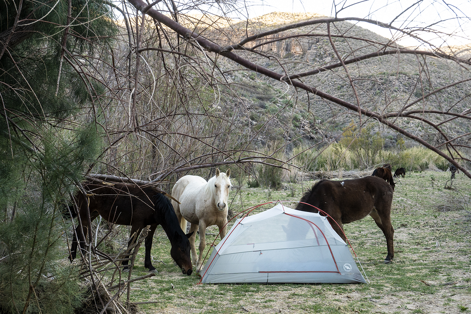
We camped the second night where we could scramble up a steep sandy bank and find our way through thorny riparian vegetation to a broad bench grazed by Mexican horses and cattle. Two caballeros, smiling and waving, had splashed their horses across the Rio Grande in front of us earlier that day, unconcerned about the international border. At camp, a horse nibbled at our tent and spooked, surprised by the feel of lightweight fabric on its tongue.


Setting up our second camp.

Curious horses wondering if tents might be good to eat.


Low water boating has been the theme of our nascent packrafting experiences. On the John Day in Oregon in 2021 (earlier blog post), there was enough water to float lazily along, but the small rapids were reduced to riffles, and route-finding was more of a challenge than pushy water. Later in the spring (April 2022) after Big Bend, we floated the Escalante from Fence Canyon to Coyote Gulch (blog post to come) at very low water and exhausted our already fading core muscles scooching the boats across gravel bars. While persistent drought in the southwest has more serious consequences than inconveniencing packrafters, one worries that the already small windows for floating desert rivers could close altogether.


Does the river end here? Not yet, but finding shallow passages around gravel bars was challenging.

Ellen paddling in flat water after leaving the canyon. 

Lunch on the last day.

Still water.

It was hot as I walked the two-track from the take-out, climbing over a locked gate and continuing up a long driveway to the Heath ranch to retrieve our van and borrow the gate key. Ellen stayed behind deflating rafts and organizing gear while a large group took-out and set up camp by the river. After an enthusiastic greeting by their friendly ranch dog, Russell and his mother offered us camping at the end of the seldom-used asphalt runway that extended from just north of their house up and over a hill and back down to a private level spot out of view of the ranch. Having chosen privacy over the river camp, we drove the runway to this surprisingly peaceful camp with views south into Mexico and north into Texas. After spreading our gear on the tarmac to dry, we cleaned up, cooked dinner, and enjoyed the warmth and fading light of a South Texas February day. 


Drying gear on the Heath Ranch runway.


Memories of trips evolve until all that’s left are a few defining moments, sometimes surprisingly mundane compared to the adventure. That evening on the runway after the float is one of these for me. We sat in our camp chairs as the sun sank behind the ridge to our west and the air cooled. Mountain peaks in Mexico lit up for a few minutes against a darkening sky and a few stars appeared. It’s seldom the paddling or the hiking you think most about months after an adventure. 


Our camp at the end of the trip.

The runway leading back to the Heath Ranch house.


Logistics: A permit is required from the Park Service for the float. You must carry a metal fire pan and an extra paddle and life preserver, even if you aren’t building fires. Put-in just upstream from Rio Grande Village in the park and take-out at Heath Ranch about 10 miles east of the park—call the ranch for permission; they are very friendly and offer camping. Charge is $10/night for parking your vehicle at the ranch. Russell Johnson or his mother will probably do the shuttle—you pick them up at the ranch and drive back to the put-in with them. Then they drive your car back to the ranch, so plan on that time and gasoline for the shuttle (you can get gas in the park but it’s expensive). We bought a river guidebook from the Big Bend Natural History Association but didn’t find it that helpful. There are two named rapids, both of which can be portaged. Camping isn’t too hard to find though as I said, the banks can be scrappy. You are asked to camp on the U.S. side. There’s more info from the park service at this link.


Wednesday, November 10, 2021

Packrafting: Oregon's John Day River


Morning on the John Day River -- June 2021

There are many ways to be remembered after you’ve died, some better than others. John Day may have preferred to remain a footnote in history, where he’s been described as a “lanky, good-natured, forty-year-old"1 hunter from Virginia who accompanied John Jacob Astor’s Astorians across the U.S. in the early 1800s in a bid to establish the first trading post on the Pacific Northwest Coast. Instead, he is immortalized in Central Oregon by a town, a river, and a national monument because he managed to stumble back to friendly settlements after being stripped naked and left in the wilderness by Native Americans perhaps in retribution for an earlier killing of two of their people by whites. The resulting PTSD by some accounts left him sometimes ranting and babbling incoherently. 


Peter Stark’s “Astoria,” an engaging book on the history of John Jacob Astor’s campaign to establish a trading presence at the mouth of the Columbia, provides more information on John Day’s fate and the difficulties of gaining a foothold in the Northwest, then a vast unmapped wilderness. Today, Central Oregon is neither wilderness nor unmapped, but it is beautiful, with rolling volcanic hills covered by grass and shrublands punctuated by forests, farms, and small towns kept alive during drought by water sucked from nearby rivers, including the John Day.


En route to our first packrafting trip, an easy 4-day float interrupted by a few minor rapids, Ellen and I stopped at three units of the John Day Fossil Beds National Monument, drove through the town of John Day, and finally, on the only rainy day in a month of traveling, along with our friends Brian and Jenny from Seattle, inflated our packrafts at Service Creek and headed down the river for four days to the Clarno takeout with flotillas of bass fisherman and families. The trip was a gentle introduction to packrafting. Drought had lowered the river enough so that the main challenges were dodging rocks and scraping bottom rather than getting pushed around in the infrequent rapids and riffles.  


 John Day died in 1819 or 1820 in Idaho at a place called “Day’s Defile.”


The John Day Fossil Beds. Trails lead only a short distance into the Monument, and off-trail hiking isn't allowed probably to prevent fossil collection.

Ellen descending from a viewpoint at the Painted Hills Unit of the John Day Fossil Beds the day before we put-in.


Rigging our boats at the Service Creek put-in on the only rainy day of the trip. Brian (left), Ellen, and I used Alpacka Expeditions, and Jenny (right) floated in the sea kayak that she built herself. The sea kayak was faster on flat water, but not as suited to rocky rapids.

On the water. After this trip, Ellen and I had our boats retrofitted so that our gear could be stored inside the inflated boat tubes rather than strapped to the bow. 

Brian consulting the river guidebook

The river from one of the volcanic bluffs near our first campsite.

Packing up for a day of floating.

Ellen and Jenny scoping the river.

The Central Oregon landscape. The vegetation was crispy dry, which seemed surprising for Oregon in June. 

Brian and Ellen cooking breakfast at camp.

Packing up.

Ellen negotiating Homestead Rapid, the biggest on the trip. We scouted it since none of us had packrafting experience, but the line was straightforward in low water and required only dodging couple of rocks. 

Packrafts make good camp chairs. 

Ellen floating on flat water towards Cathedral Peak.

Camping in the Oregon Badlands SW of the takeout after the trip. 

1. Stark, Peter. 2014. Astoria: John Jacob Aster and Thomas Jefferson's Lost Pacific Empire: A Story of Wealth, Ambition, and Survival. Ecco. 403 pgs.