Friday, December 10, 2021

Mountain Biking: The White Rim

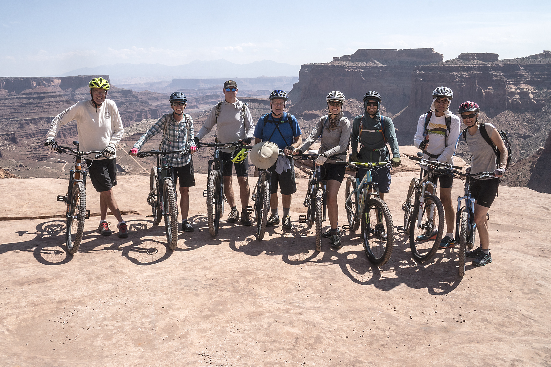
Looking out over the first part of the smoky, hot (90s) White Rim from the Shafer Overlook. 
(Click images to view larger)

On the first of three nights spent on the White Rim Trail we camped at the exposed Airport site, and after dinner, the 90+ degree cloudless day gave way to violent wind and lightning. We did our best to hold our tents together. I plastered myself against the windward wall of our Big Agnes Copper Spur 2, while Ellen lay on her back supporting the poles with her feet and the opposite wall with her arms. One pole snapped and ripped through the fly, but we stayed mostly dry even as blowing sand filtered through netting onto our pillows and sleeping bags. After more than an hour of wind (60 mph? 70mph? more?) and just enough rain and hail to turn the dust to mud, the storm moved on, and we reunited in the dark with our friends to assess the damage, comb the desert downwind of camp for lost crap, and compare stories. Despite the violent storm, it never got even remotely cool.

The trip included eight of us from all over the West (Laramie, Boulder, Ft. Collins, Bisbee, Seattle). We mountain biked the route over four days in mid-September, when temperatures each day hovered in the 90s and low 100s, well above "normal" for that time of year, but not that unusual either. 90s and 100s are less ideal than other temperatures, but despite the heat and wildfire smoke, it was a very fun trip--much more fun, for example, than the plethora of pandemic-spawned Zoom meetings (graphic below) all of us have faced.

The world has changed since the last time I was on the White Rim decades ago. Mountain biking wasn't even a thing then, when, with no permit required, friends and I camped for a week in Taylor Canyon to climb Moses and Zeus (sandstone spires) and didn't see another soul. Moab, then relatively sleepy, is now a hellscape of ATVs, traffic, tourists, hotels, restaurants, and t-shirt stores; it's hotter and smokier in the West every year; covid rages; and mountain bikers (including us) are everywhere. Despite that, the White Rim remains beautiful and uncrowded. What a pleasure, even in the heat, to ride with good friends along the Colorado and Green Rivers, past Wingate cliffs with spires coming into view around every corner and good meals at every camp. 

Here are a few photos from our trip, and a little information follows on logistics. 

Daytime temperature on the White Rim vs. Enjoyment. (graph concept copied from semi-rad.com).


(L to R): Me, Ellen, Brian Collins, Larry Scritchfield, Allie Ruckman, Ben Leonard, Bret Ruckman, Judy Ruckman. We were barely sweating at all before we started riding.

Shafer Overlook: Larry looking down at the Shafer switchbacks--the descent route to the White Rim. 

Day 1: Bret pointing out Crow's Head Spire, a climbing destination. We camped on the rim near there after finishing the 4-day ride.

Day 1: White Rim sandstone capping mini-spires along the rim. 

Day 1: Musselman Arch. Walking across it is prohibited, but rumor has it that it's been traversed by ATVs (and probably motorcycles). 

Day 1: One of many enticing canyons cut into the White Rim. The heat kept us from getting too enticed though. 

Camp 1: Not so ominous (we thought) storm clouds gather near our first camp at the exposed Airport site. After we retired for the night, the storm unleashed 60-70 mph wind and rain, hail, and lightning for over an hour, during which we all fought private battles to keep our tents from being tattered and rolled across the desert. It was engaging and amusing.

Camp 1: Larry (R) and Brian (L) set up their tents at the Airport site. Unlike some of us, they had the wisdom to attach their tent flies BEFORE the wind reached tropical storm force.

Camp 1 (morning): The next morning, Ellen (L) and Judy (R) compare notes on how to hold a tent up with your feet in 60+ mph wind.

Camp 1 (morning): The storm-battered crew prepares for the second day of riding. 

Day 2: Bret riding with Monster and Washer Woman Towers in the background.

Day 2: Allie and Judy share the shade of an umbrella. My umbrella self-destructed at our first rest stop on day 1 ($5.99 just doesn't buy the quality it used to), so I was left with only my hat for shade.

Day 2: Bret standing on the rim of an enormous alcove undercutting the road/trail.

Day 2: 90s? 100s? Shade?

Day 2: Ellen approaching the steep climb to Murphy's Hogback near the end of the second day of riding.

Danny McGee, our sag driver. He works occasionally for Rim Tours, a Moab outfitter. Rim Tours was great to work with, and Danny was incredibly accommodating and patient as we wobbled along in the heat. He's a climber and knew Bret from Boulder, so there was an immediate connection.  

Camp 2 - Murphy Hogback: We camped on top of the Murphy Hogback after walking our bikes up the steep hill that leads up it. We enjoyed great views from the camp and no more storms.

Camp 2: Bret organizing his and Judy's tent on Murphy's Hogback as the sun set. 

Day 3: Watching freshwater shrimp in a pothole at Black Crack. Black Crack is a deep fissure that runs parallel to the rim for hundreds of meters where a part of the White Rim sandstone is separating from the rim.

Day 3: Brian taking refuge in a rare spot of shade on a day when a passing 4WD group told us it was 103 degrees. 

Day 3: Lunchtime in the shade where the trail crosses the Holeman Slot. After lunch, we descended partway down the slot, which was shady and full of pools of water. 

Day 3: Bret spotting Judy on a downclimb in the slot. With muddy feet, The slab below him was the crux of the climb out on our return.

Day 3: Fixing a flat tire in the shadeless desert.

Camp 3: Sundown at Hardscrabble Bottom on the Green River, our last camp. After a day of riding in 100+ degree blazing sun, we lowered our body temperatures in the Green River and sat in the shade of an awning drinking beer.

Camp 3: Bret with bacon! Breakfast on our last day.

Day 4: Sunrise. Hardscrabble Bottom.

Day 4: Allie and Ben ride along the Green with youthful enthusiasm on the last day. Morning shade made youthful and oldful enthusiasm more achievable.

Day 4: Back to the car shuttle at the top of Mineral Bottom.

Camp -- post trip: Crow's Head Spire from the rim (see earlier picture). Ellen and I camped with Bret, Judy, Allie, and Ben near here before we all headed off in different directions.

Logistics

We rode from Shafer to Mineral Bottom, which seemed good, but people ride the other way too. 

There's no shortage of information online about the White Rim (see links below). The challenge is reserving well-spaced campsites along the way; our strategy was for 3 of us to hover over our keyboards on the day they opened up reservations for the time slot we wanted. The camps we got (Airport, Murphy's Hogback, Hardscrabble) were pretty good--Murphy's was great. White Crack seems to be the camp everyone wants to get, but we weren’t fast or lucky enough to grab it. 

We paid Rim Tours to sag our trip so that all of us could ride every day and to save our own vehicles from the rough road. Most of the road was good, but the climbs up Murphy’s Hogback and Hardscrabble Hill seemed a little gnarly, and there were some deep mud holes on the last day. Presumably, the road gets graded now and then (??), but I was glad we didn’t drive it ourselves. 

We bought food as a group and took turns cooking and cleaning up. That worked well on our trip, but required a lot of planning with a big group. The alternative would be for everyone to buy their own food and cook for themselves. That choice is just a matter of group preference. 

See the following for more info:


Wednesday, November 24, 2021

Photographing Autumn in the Shadow of Eliot Porter


Maple Canyon, Utah. October 2021 
(Click on photos to view larger versions)

Eliot Porter's (1901-1990) photographs evoked his love of the natural world, and his work has influenced photographers for decades. He was an early advocate for color in fine art photography, an innovation resisted by photographers and critics who saw color photography as purely documentary even into the 1980s. In black and white prints they insisted, colors are rendered as tones at the discretion of the photographer, and these choices are the basis of art. In the book, Eliot Porter, he reported that Walker Evans, another influential photographer, once griped, "...in I suspect a reckless, not-to-be-quoted moment, that color is vulgar, nature is trivial, and beauty is not important."1 Porter believed just the opposite.

Eliot Porter photographed intimate details in natural scenes rather than grand landscapes. Layers of texture and pattern combined to fill his frames, which were at once simple and complex. Weston Naef, in the Afterword of the folio, Intimate Landscapes that accompanied a 1979 exhibition of his work at the Metropolitan Museum of Art in New York, observed that:

"His strongest compositions have the look of carefully planned randomness in which the surface is a tapestry of uniformly significant elements arrayed from one edge of the picture to the other." (pg. 126)2

Eight years later, Martha Sandweiss, a curator at the Amon Carter Museum, in the foreword to the book, Eliot Porter, documenting her museum's 1987 exhibit of his photographs, echoed this view:

"Porter's pictures are generally composed without a single eye-catching focus. Each is carefully laid out from edge to edge, and the picture frame feels full" (pg. 8)1

While the arrangements of elements in natural scenes are deterministic, the result of their interactions can appear random. Over time, Porter became increasingly aware of the paradox of random processes creating harmonious compositions. In the preface to Intimate Landscapes, he says, 

"In mixed woods of pine and maple, the needles of pines drop throughout the year, building jackstraw mats of thin brown bundles on which, at the time of the fall of the leaf, the bright maple leaves settle at random, arranging themselves in harmonious patterns that defy improvement as though placed there intentionally." (page 11) 2

And he notices, not without awe, that: 

"The details of geologic formations exhibit the most extraordinary combination of shapes and colors...and the haphazard occurrence of fractures can be discovered in harmonious arrangements that seem to defy the chance working of natural forces" (pgs. 11-12)2

His fascination with the paradox of harmony in randomness led eventually to a collaboration with James Gleick, who made chaos theory accessible in his book, Chaos: Making a New Science.4 Gleick and Porter published Nature's Chaos in 1990 with text by Gleick and a selection of images by Porter. In the forward to that book, Porter reflected that:

"Although I was aware that it was possible to select and photograph fragments of nature that expressed the idea that nature was an orderly process, I began to realize that my photographs also emphasized the random chaos of the natural world--a world of endless variety where nothing was ever the same." (pg. 6)3

In Intimate Landscapes, Porter succinctly describes the challenge of photographing randomness in a way that highlights harmony:

"In the broadest sense of the term, an optical image is an abstraction from the natural world--a selected and isolated fragment that stands before the camera." (pg. 11)2

This is much more difficult than it sounds, but over his 50-year career, Porter relied on a practiced intuition that resulted in an unmatched body of work. 


Freed from teaching, I spent much of the fall traveling in the West, grateful to wander, watching the seasons and the leaves change. Faced with hillsides and canyons awash in yellow, red, and green foliage; punctuated by aspen, oak, maple, and cottonwood trunks; interrupted by deadfall; fragmented by meshes of bare branches; and all draped over topography and geology, it seemed impossible not to limp along in Porter's footsteps. 


Central Oregon. September 2021

Central Oregon. September 2021

Central Oregon. September 2021

Central Oregon. September 2021

Chuckanut Mountains, Western Washington. September 2021

Manti-La Sal National Forest, Utah (Rt. 31). October 2021

Manti-La Sal National Forest, Utah (Rt. 31). October 2021

Manti-La Sal National Forest, Utah (Rt. 31). October 2021

Maple Canyon, Utah. October 2021

Todie Canyon, Utah. October 2021

Blue Jay and yellow leaves, Hovenweep National Monument, Utah. October 2021

Juniper berries, Comb Ridge, Utah. October 2021.

References

1Eliot Porter: Photographs and Text by Eliot Porter. 1987. Published by New York Graphics Society Books, Little, Brown and Company, Boston, in association with the Amon Carter Museum. 

2Intimate Landscapes: Photographs by Eliot Porter. 1979. The Metropolitan Museum of Art, New York. E.P. Dutton. 

3Natures Chaos. 1990. By James Gleick and Eliot Porter. Viking Penguin. Penguin Books, New York. 

4Gleick, James. 1987. Chaos: Making a New Science. Penguin Books, New York.


Wednesday, November 10, 2021

Packrafting: Oregon's John Day River


Morning on the John Day River -- June 2021

There are many ways to be remembered after you’ve died, some better than others. John Day may have preferred to remain a footnote in history, where he’s been described as a “lanky, good-natured, forty-year-old"1 hunter from Virginia who accompanied John Jacob Astor’s Astorians across the U.S. in the early 1800s in a bid to establish the first trading post on the Pacific Northwest Coast. Instead, he is immortalized in Central Oregon by a town, a river, and a national monument because he managed to stumble back to friendly settlements after being stripped naked and left in the wilderness by Native Americans perhaps in retribution for an earlier killing of two of their people by whites. The resulting PTSD by some accounts left him sometimes ranting and babbling incoherently. 


Peter Stark’s “Astoria,” an engaging book on the history of John Jacob Astor’s campaign to establish a trading presence at the mouth of the Columbia, provides more information on John Day’s fate and the difficulties of gaining a foothold in the Northwest, then a vast unmapped wilderness. Today, Central Oregon is neither wilderness nor unmapped, but it is beautiful, with rolling volcanic hills covered by grass and shrublands punctuated by forests, farms, and small towns kept alive during drought by water sucked from nearby rivers, including the John Day.


En route to our first packrafting trip, an easy 4-day float interrupted by a few minor rapids, Ellen and I stopped at three units of the John Day Fossil Beds National Monument, drove through the town of John Day, and finally, on the only rainy day in a month of traveling, along with our friends Brian and Jenny from Seattle, inflated our packrafts at Service Creek and headed down the river for four days to the Clarno takeout with flotillas of bass fisherman and families. The trip was a gentle introduction to packrafting. Drought had lowered the river enough so that the main challenges were dodging rocks and scraping bottom rather than getting pushed around in the infrequent rapids and riffles.  


 John Day died in 1819 or 1820 in Idaho at a place called “Day’s Defile.”


The John Day Fossil Beds. Trails lead only a short distance into the Monument, and off-trail hiking isn't allowed probably to prevent fossil collection.

Ellen descending from a viewpoint at the Painted Hills Unit of the John Day Fossil Beds the day before we put-in.


Rigging our boats at the Service Creek put-in on the only rainy day of the trip. Brian (left), Ellen, and I used Alpacka Expeditions, and Jenny (right) floated in the sea kayak that she built herself. The sea kayak was faster on flat water, but not as suited to rocky rapids.

On the water. After this trip, Ellen and I had our boats retrofitted so that our gear could be stored inside the inflated boat tubes rather than strapped to the bow. 

Brian consulting the river guidebook

The river from one of the volcanic bluffs near our first campsite.

Packing up for a day of floating.

Ellen and Jenny scoping the river.

The Central Oregon landscape. The vegetation was crispy dry, which seemed surprising for Oregon in June. 

Brian and Ellen cooking breakfast at camp.

Packing up.

Ellen negotiating Homestead Rapid, the biggest on the trip. We scouted it since none of us had packrafting experience, but the line was straightforward in low water and required only dodging couple of rocks. 

Packrafts make good camp chairs. 

Ellen floating on flat water towards Cathedral Peak.

Camping in the Oregon Badlands SW of the takeout after the trip. 

1. Stark, Peter. 2014. Astoria: John Jacob Aster and Thomas Jefferson's Lost Pacific Empire: A Story of Wealth, Ambition, and Survival. Ecco. 403 pgs.