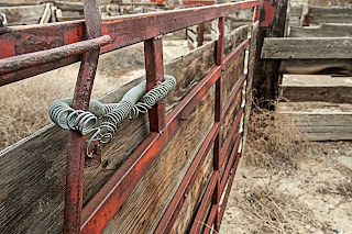
A farm building in the southern Bighorn Basin, Wyoming.
(click images to view larger)
I started this post a little over three years ago and never finished it after getting wrapped up with new (then) work responsibilities. Now retired, I'm cleaning up old blog drafts, and I enjoy these images enough to publish this without much text. For those who aren't familiar with the geography, the Bighorn Basin occupies a large area in north-central Wyoming between the Bighorn Mountains to its east and the Absaroka and Beartooth Mountains and Yellowstone National Park to its west. The Owl Creek and Bridger Mountains wrap around the southern edge of the basin and the Pryor Mountains rise just over the Montana border to the north. The basin is sparsely populated and agricultural where there is water to irrigate and very dry elsewhere, occupied by sparse shrublands and a lot of saltbush. It's a beautiful place to explore.
Wyohistory.org has an excellent overview of the basin and its history that I won't paraphrase here. The photos in this post were collected during several excursions.
Grain elevator, Greybull.
Trees, Northern Bighorn Basin.
Gate. Greybull Livestock Auction.
Trailer with statues. Greybull.
Boulder, Red Gulch. Eastern Bighorn Basin.
Stop and Proceed.
Rags. Industrial area, Greybull.
Greybull Livestock Auction.
Chairs. Greybull Livestock Auction.
160-180 million year old dinosaur track, Red Gulch. Species unknown (Therapod?)
Chute, Greybull Livestock Auction
Chute, Greybull Livestock Auction
Greybull Livestock Auction.
Trees and wind leave their mark, Greybull Livestock Auction.
Badlands, Eastern Bighorn Basin.


