Showing posts with label Collins Spring. Show all posts

Tuesday, February 1, 2022

Backpacking in Grand Gulch: Collins Spring to Kane Gulch


Scott Lehman at one of my favorite petroglyph panels.
(Click on images to view larger)

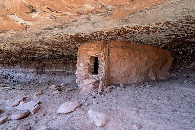
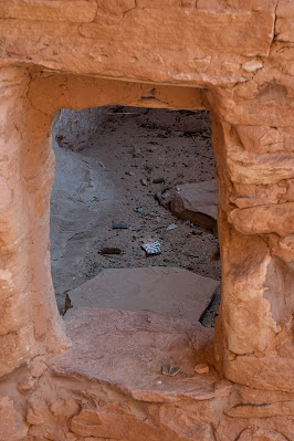
When I first visited Cedar Mesa in the 1980s, Grand Gulch was obscure, with word-of-mouth descriptions of arduous bushwacking and secret ruins. Since then, guidebooks have been published, books written, and the Bears Ears National Monument created, diminished, and finally restored, hopefully forever. A growing number of people hike regularly in the Gulch and its tributaries, and it seems that everyone has a secret undisclosed discovery, enticing the rest of us to keep looking. Despite growing popularity, it remains one of my favorite places; no one will ever peer into every hidden alcove or look behind every exfoliated boulder to find the last undiscovered treasure, and even without its cultural heritage, Grand Gulch is stunning. 


In March of 2021, I spent a week with Ellen and our friends, Scott and Bay, hiking from Collins Spring to Kane Gulch, about 38 miles. We’d all walked much of this section and many of its side canyons before but in pieces on many trips over many years, so it was fun to traverse it in one hike. 


While the walking was easy (we planned short days to leave time for ruins and rock art), the drought presented challenges. Water in much of the canyon had disappeared, and hikers, us included, planned our days and camps around what little water could be found, some barely drinkable even with filtering. I recently wrote about climate migrations in the Southwest, partly stimulated by this experience of traversing the canyon in a dry year. Until about 700 years ago, it supported a thriving Ancestral Puebloan community. The gist of that post was that drought destabilized their society, leading to abandonment. 


While on this hike, I realized that drought need not be long-term to drive people out. After a few years without good monsoon rains or winter snow, most of the water was gone. How long could permanent residents of Cedar Mesa live and farm without regular rain? A few years? A decade? How much water could they store from ephemeral summer showers or winter snow? Are there enough obscure springs to sustain a substantial population through several dry years? I don’t know the answers to these questions, but when we were in the canyon in March, there was barely water to support a few dozen backpackers on their vacations, passing through the canyon for only a few days. 


These are a few pictures from our trip. Except for some of the well-known sites, I don't specify locations.


Ellen and Bay (not Bei, our daughter!) enjoying pictographs in a Rincon north of the junction of Grand Gulch and Collins Spring.

The Bannister Ruin. We camped near here on the first night. Bannister spring was dry (we carried water from the trailhead) but I scrambled to a pothole above the canyon floor that was filled with good water.

An arrowhead found in the wash and returned to it after being admired. I recommend Craig Child's book, "Finders, Keepers" for those of you interested in respecting archeological finds.

Handprints.

Routefinding is not too tough when you are following a major canyon, but keeping track of side canyons requires some attention.

A small man (me), and woman (Ellen) sit below the Big Man Panel north of Polly's Canyon. 

More handprints. Bay recreates the moment.

An intact granary tucked beneath a reticulated roof.

The bird panel. I carried my lightweight backpacking camera without a very long lens, and these were high above the canyon floor, but you can zoom in to see better. The pictographs are exquisitely detailed. 

Ellen and Bay scrambling to see a ruin and rock art in a side canyon.

Bay (left) and Ellen enjoying rock art.

The breech birth panel. 

Our camp on a ledge above Coyote Canyon. The spring in the canyon bottom produced good water.

A potsherd inside a ruin.

A wall tucked behind a fallen boulder, with pictographs lined up under the arch behind it.

Bay admiring a petroglyph panel at the mouth of Todie Canyon.

After the hike. Left to right: Bay Roberts, Scott Lehman, Ellen Axtmann, and me.

Water info: Grand Gulch was very dry after a multi-year drought and the failure of the monsoon the previous summer. We found water in a pothole (ephemeral) at our first camp near the Banister ruin on a slickrock shelf that required scrambling to access. There was water in lower Collins Canyon and for short way up Grand Gulch from the confluence, and again in pools in the main Gulch just downcanyon from Polly's. Water was available a short way up Green Canyon and farther along in Green Mask Canyon below the well-known rock art site. The Coyote Canyon spring was running. Farther up, we filtered nasty water from a pool under a pouroff down canyon from the mouth of Todie Canyon. We were told that there was water up Todie in the North Fork, but we used our filtered water instead. From there, we walked out to Kane Gulch. 

Don't rely on the BLM office in Monticello, though they may have some information. If the Kane Gulch Ranger Station is open, it’s a more reliable source of information. Of course, there can be much more or much less (!) water depending on the year. 

Another much more detailed blog post on this hike going in the other direction is at this link and there are many other detailed accounts online if you search for them.


Saturday, March 26, 2016

Spring Break: Cedar Mesa Ruins

A structure in Step Canyon, one of the side canyons of Grand Gulch on its northwest side.
(Click images to view larger)

We spent our spring break on Cedar Mesa (Utah) again this year, along with my sister, Kim, her husband T and son Ruess (named after Everett), my other sister’s son, Manny, and our Laramie friends, Dave Fay and Amy Fluet and their kids, Sam and Eliza. It was a big group, so we camped at Natural Bridges, but we left each day to explore a different canyon or site.

We don’t go to Cedar Mesa every year, but it’s one of my favorite places. Not only are the canyons beautiful, but they are full of the remains of thousands of years of human use. The last major occupation, not counting our group, ended suddenly around 1200 A.D. for reasons that remain unclear: drought or conflict are the most common explanations. It’s estimated that at least a half million people must be buried across the mesa, many near cliff dwellings that can still be visited, or associated with pit houses that are harder to find. Unfortunately, many (most?) of the sites have been ravaged by pot hunters, most infamously from Blanding, though certainly not exclusively so. I’ve never found an intact pot, though potsherds are everywhere.

I recently read Finders Keepers: A Tale of Archaeological Plunder and Obsession, by the Craig Childs, the long-time desert explorer and writer. Childs does an exceptional job of probing the tension between our urge to find and keep treasures (or more basely to sell them for financial gain) and the value of leaving sites and artifacts intact out of respect for their originators and for the enjoyment of those who will come exploring after us. “At this point,” Childs says in the book, “considering all that has been removed, it is worth leaving the last pieces where they lie.”

I think it is Childs (I’ve read several of his books on the SW) who speaks of living museums, places where he has found and left significant artifacts, mapped only in his memory.

I haven’t spent enough time on Cedar Mesa to join the ranks of those (there are more than a few) who know of secret sites and perhaps have their own living museums of intact artifacts, but I have poked my head into enough hidden alcoves, some obscure, to know that little has been left undisturbed. Cedar Mesa is a beautiful place, and too topographically complex for any one person to ever know completely, and that gives every canyon its own mystique.

An unusually large potsherd: Step Canyon

Bei in Step Canyon

Bei looking at potsherds washed downslope from a midden and ruin. Step Canyon.

Sam Fay levitating his sister, Eliza, at the trailhead for Collins Spring Canyon.

Random stuff in an old cowboy camp under an alcove in Collins Spring Canyon.

Bei, Eliza and T in the "Narrows" of Grand Gulch, just downstream of its junction with Collins Spring Canyon.

Kim and T hiking out to the Citadel Ruin, which is perched on a peninsula of sandstone high above Road Canyon.

The down-scramble to the Citadel approach.

Ellen just before the long rock bridge to the Citadel.

Lunch at the Citadel, with Sam Fay using his orange skin to illustrate the level of recent Presidential Primary debate. And from another time: Nixon's head is in the background.

The Citadel.

The Citadel ruin, from the approach.

Leaving the Citadel site by crossing the sandstone rib that leads to it.

Desert pothole near the Citadel.

Descending into McCloyd Canyon to visit the Moon House ruin.

Inside the front hallway of the Moon House. 

Kim emerging from the Moon House.

The painted hallway of the Moon House.

Cousins: Bei, Manny, and Ruess.  

A smaller ruin near the Moon House.

Ruins along the ledge to the right of the Moon House.

Family photo at the Moon House. Top L to R: T, Manny, Ruess. Bottom L to R: Ellen, Bei, Kim, me.

The Fluet-Fays at the Moon House: L to R: Amy, Sam, Eliza, Dave.


Hiking on the ledge below the Moon House.

Climbing back out of McCloyd Canyon.

Kim and her family put the rest of us to shame at mealtime. Here they cook pre-prepped Kielbasa, while the rest of us prepare our pitiful camping food. They were kind enough to share with those of us who crave meat.

A ruin in the Fishmouth Cave area along Comb Ridge, south of Hwy. 95.