Showing posts with label Anasazi. Show all posts

Monday, December 13, 2021

Ancestral Puebloans and Climate Migration


The Dollhouse Ruin in the Bear's Ears region.
(Click on images to view larger)

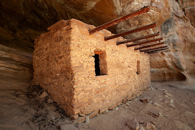
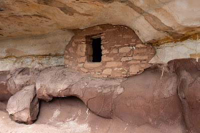
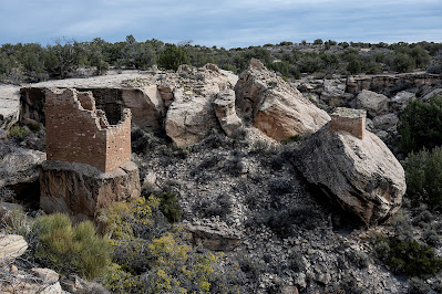
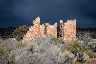
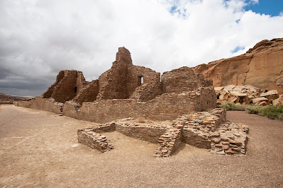
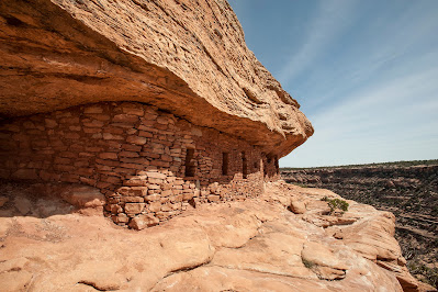
The U.S. desert southwest is remarkable in its concentration of archaeological sites, relics of the Ancestral Puebloans who occupied the Four Corners region until about 1300 AD when, somewhat mysteriously, they left. Anthropologists have pondered the abandonment of places like Cedar Mesa, Chaco Canyon, and Mesa Verde for over a century, and many theories have emerged to explain why these people abandoned elaborate structures and a well-developed civilization. The simplest explanation is that a “megadrought” in the late 1200s drove them out, but hypotheses are more nuanced, invoking resource depletion, violence from both within and outside, the breakdown of complex religious hierarchies, and increased vulnerability to environmental change caused by reliance on agriculture, to name a few. 


Reliance on corn may have been a mixed blessing for Ancestral Puebloans because of increased vulnerability to changes in climate. (Comb Ridge, October 2021).

A granary on Cedar Mesa used for storing corn. (October 2021)

There is general agreement that by 1300, most of the sites across the Four Corners were abandoned. Evidence suggests that the Ancestral Puebloans migrated south and integrated with Hopi and Zuni peoples and other groups in the Rio Grande drainages, though it is still unclear why they moved from one dry place to another. What is clear is that environmental pressure led to a breakdown in society that culminated in abandonment and migration.


Masterfully constructed structures at Hovenweep National Monument, Utah. Why were these built on boulders? (October 2021)

A ruin at Hovenweep as a storm builds in the distance. (October 2021)

While I was in the Southwest this fall, I read Douglas Preston’s book, Talking to the Ground, about a 400-mile horseback trip he and his family took in 1992 across the Navajo Reservation, tracing creation stories and talking with Navajo people along the way. In his 2019 epilogue, Preston espouses the idea that Chacoan power hierarchy depended on the belief that religious leaders controlled the rain, a strategy that worked well for them in wet years but not so well when multi-year drought inevitably arrived. This led to violence and the breaking of bonds holding geographically disparate groups together. Though theories continue to evolve, the gist remains the same—drought-caused stress catalyzed changes leading to abandonment of vast areas and dissolution of a well-developed civilization. Preston writes: 

“What we know is this: one thousand years ago, the Anasazi embarked on a great religious experiment at Chaco Canyon, an experiment based on the (illusory) control of nature. It was an experiment whose ultimate consequences the Anasazi did not foresee. And it failed.” (Preston pg. 261) 


Ruins at Chaco Canyon (June 2018).

The well-known Citadel ruin on Cedar Mesa. Did ruins become more defensive as resources became scarce? (March 2016)

2008 New York Times article by George Johnson acknowledges this idea but suggests that abandonment may have been less sudden, though still ultimately driven by changing environmental conditions. The article concludes:


“Amid the swirl of competing explanations, one thing is clear: The pueblo people didn’t just dry up and blow away like so much parched corn. They restructured their societies, tried to adapt and when all else failed they moved on.”


We still have marks on door trim in our house showing our daughter's height as she grew up. Maybe the handprints above this dwelling were the same. We think of ancient migrations in the abstract, but these were people like us whose lives were uprooted. (Cedar Mesa, March 2017)


Migrations in response to changing climate were not new, even in 1300. The populating of the Americas was mediated by the last ice age as people crossed the land bridge from Asia and walked southward. Further back, there is evidence that waves of migration of Homo sapiens from Africa into southern Europe beginning almost 100,000 years ago may have been driven by periodic climate changes that opened green corridors between Africa and the Arabian Peninsula.

Humans have always moved to more favorable environments when they could.

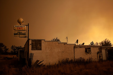
In September (2021) on our way to SE Utah to camp, hike, and visit ruins, we drove along I-70 in Colorado through the heavy smoke of the 2021 fire season, entering Glenwood Canyon where an extensive wildfire the previous year had denuded the canyon walls of vegetation. Earlier in the summer, unusually heavy monsoon rains generated enormous landslides, trapping people in their cars, briefly damming the Colorado River, and decimating parts of the highway, which was still being repaired months later. We arrived in Utah during an unseasonable heat wave and sweltered for several weeks before it finally cooled down. These extremes—wildfires, torrential rain, landslides, heat—are signs of a changing climate, but unlike the changes in the 1200s, modern climate change is global, not regional. 

Even in 1995, Douglas Preston and the Navajo people he visited were aware of modern parallels to the Chacoans:


“As the twentieth century draws to a close, we find ourselves in a similar effort to control nature, only this time on a much larger scale. Our experiment is not based on ritual but on technology. We believe, as the Chacoans did before us, that we have gained a certain mastery over nature. Our God gave us dominion.


The question is: have we really achieved it? Could our mastery of nature be as much an illusion as the rain ceremonies of the Chacoans? Are we, like the Anasazi, headed for an environmental or technological disaster?” (Preston pgs. 261-262 of )


Today, Preston’s last question seems quaint. The answer is clear, but still we struggle to respond in a meaningful way to the increasing concentration of greenhouse gasses we spew into the thin film of atmosphere clinging to the earth.


Wildfire smoke during the Mullen Fire west of Laramie, Wyoming. Smoky summers are part of our lives now. Ten years ago they were the exception. (September 2020)


During his journey, Preston speaks with a Navajo man named Edsel Brown. The Navajo, who themselves once migrated from the northwestern North America to the desert, believe that the earth is a living relation rather than a “resource.” Edsel Brown tells Preston (emphasis at the end is mine):

“This cycle goes back to a long time ago. It goes back to the first invention that was created. It goes back to when the Bilagaana [white man] realized that they had the power to make things. They had the power to create things. And they started to look on the land as a resource. They didn’t look at the land as relatives, as living beings, which it is. And they made these inventions, electricity, dams, cars, bombs, pesticides, everything. They kept thinking that all these inventions would help them. And yet, they’re still not helping them. And now, today, things are starting not to work for them, and they have no place to go, and they have a hard time realizing what is happening.” (Quote from a Navajo man, Edsel Brown in Preston, pgs. 263-264)

It’s hard for us to see changes that happen over decades or centuries, but the effects of climate change are increasingly obvious. Are we creating our own ruins? Who will visit them?


Ruins and graffiti at an abandoned industrial site in Laramie (2011). Where will we migrate?


Sunday, December 17, 2017

The Kaiparowits Plateau

Collet Top Arch and granary on the Kaiparowits Plateau.
(Click on images to view larger)

Last May (2017), before Donald Trump and Ryan Zinke decided, against the will of the vast majority of 2.8 million public commenters, to radically shrink the Bear’s Ears and Grand Staircase-Escalante National Monuments, I drove the Smoky Mountain Road across the Kaiparowits Plateau on my way to the Grand Canyon.

Like many who have hiked in the more accessible and popular canyons of the Escalante River (link, link, link, link), I’d always been curious about the Kaiparowits, looming to the southwest above the Straight Cliffs. It is notable for many reasons, but the ones that conflict the most in today’s politics are its size, remoteness, and lack of human impact versus the enormous amount of coal that lies beneath it. I fear that the recent decision to shrink National Monuments has more to do with this coal than anything else, and removing it would destroy all of the other qualities of this place, perhaps as rugged and untrammeled as anywhere in the lower 48 states.

Of the relatively few people who have spent any time on the Kaiparowits, most have done what I did—spent a couple of days driving the Smoky Mountain Road and day-hiking. A few are more ambitious, crossing the plateau on the Hayduke Trail, or finding their own routes through the dry, incised terrain (link, link).

Help protect the Kaiparowits by calling your senators and representatives and by supporting organizations like the Southern Utah Wilderness Alliance (SUWA).

Kaiparowits landscape from the southern portion of the Smoky Mountain Road.

Claret Cup Cactus, Kaiparowits.

Last Chance Creek -- a rare source of reliable water on the dry plateau. I camped here.

Cottonwood, Last Chance Creek.

Water in Last Chance Creek.

Dry Fork, Last Chance Creek. I tried to hike down this, but quickly was forced out of the canyon by a pour-over and couldn't find a way back in.

Bone, Kaiparowits Plateau.

Moonset, Kaiparowits.

Prince's Plume, southern edge of the plateau.

Southern escarpment of the plateau above Bigwater, Utah.

View southwest from the southern edge of the plateau.

Boulder near Bigwater, Utah. I found chalk on some of these boulders

Boulders and badlands below the Kaiparowits near Bigwater.

Saturday, March 26, 2016

Spring Break: Cedar Mesa Ruins

A structure in Step Canyon, one of the side canyons of Grand Gulch on its northwest side.
(Click images to view larger)

We spent our spring break on Cedar Mesa (Utah) again this year, along with my sister, Kim, her husband T and son Ruess (named after Everett), my other sister’s son, Manny, and our Laramie friends, Dave Fay and Amy Fluet and their kids, Sam and Eliza. It was a big group, so we camped at Natural Bridges, but we left each day to explore a different canyon or site.

We don’t go to Cedar Mesa every year, but it’s one of my favorite places. Not only are the canyons beautiful, but they are full of the remains of thousands of years of human use. The last major occupation, not counting our group, ended suddenly around 1200 A.D. for reasons that remain unclear: drought or conflict are the most common explanations. It’s estimated that at least a half million people must be buried across the mesa, many near cliff dwellings that can still be visited, or associated with pit houses that are harder to find. Unfortunately, many (most?) of the sites have been ravaged by pot hunters, most infamously from Blanding, though certainly not exclusively so. I’ve never found an intact pot, though potsherds are everywhere.

I recently read Finders Keepers: A Tale of Archaeological Plunder and Obsession, by the Craig Childs, the long-time desert explorer and writer. Childs does an exceptional job of probing the tension between our urge to find and keep treasures (or more basely to sell them for financial gain) and the value of leaving sites and artifacts intact out of respect for their originators and for the enjoyment of those who will come exploring after us. “At this point,” Childs says in the book, “considering all that has been removed, it is worth leaving the last pieces where they lie.”

I think it is Childs (I’ve read several of his books on the SW) who speaks of living museums, places where he has found and left significant artifacts, mapped only in his memory.

I haven’t spent enough time on Cedar Mesa to join the ranks of those (there are more than a few) who know of secret sites and perhaps have their own living museums of intact artifacts, but I have poked my head into enough hidden alcoves, some obscure, to know that little has been left undisturbed. Cedar Mesa is a beautiful place, and too topographically complex for any one person to ever know completely, and that gives every canyon its own mystique.

An unusually large potsherd: Step Canyon

Bei in Step Canyon

Bei looking at potsherds washed downslope from a midden and ruin. Step Canyon.

Sam Fay levitating his sister, Eliza, at the trailhead for Collins Spring Canyon.

Random stuff in an old cowboy camp under an alcove in Collins Spring Canyon.

Bei, Eliza and T in the "Narrows" of Grand Gulch, just downstream of its junction with Collins Spring Canyon.

Kim and T hiking out to the Citadel Ruin, which is perched on a peninsula of sandstone high above Road Canyon.

The down-scramble to the Citadel approach.

Ellen just before the long rock bridge to the Citadel.

Lunch at the Citadel, with Sam Fay using his orange skin to illustrate the level of recent Presidential Primary debate. And from another time: Nixon's head is in the background.

The Citadel.

The Citadel ruin, from the approach.

Leaving the Citadel site by crossing the sandstone rib that leads to it.

Desert pothole near the Citadel.

Descending into McCloyd Canyon to visit the Moon House ruin.

Inside the front hallway of the Moon House. 

Kim emerging from the Moon House.

The painted hallway of the Moon House.

Cousins: Bei, Manny, and Ruess.  

A smaller ruin near the Moon House.

Ruins along the ledge to the right of the Moon House.

Family photo at the Moon House. Top L to R: T, Manny, Ruess. Bottom L to R: Ellen, Bei, Kim, me.

The Fluet-Fays at the Moon House: L to R: Amy, Sam, Eliza, Dave.


Hiking on the ledge below the Moon House.

Climbing back out of McCloyd Canyon.

Kim and her family put the rest of us to shame at mealtime. Here they cook pre-prepped Kielbasa, while the rest of us prepare our pitiful camping food. They were kind enough to share with those of us who crave meat.

A ruin in the Fishmouth Cave area along Comb Ridge, south of Hwy. 95.