Showing posts with label petroglyphs. Show all posts

Monday, May 20, 2024

Lower Gila Box Canyon, New Mexico


Cliffs in one of the side canyons of the Lower Gila Box in New Mexico.
(Click images to view larger)

In 1983, the late M.H. Salmon and his dog, Rojo, hiked from the source of the Gila River in the Aldo Leopold Wilderness to where it emerges from the mountains near Gila, NM. There, he picked up his cat and canoed through three box canyons (the Upper, Middle, and Lower) in New Mexico and another (
the Gila Box) in Arizona, ending his trip before the river succumbed to agricultural diversion on its way to join the Colorado near Yuma, Arizona. He called his animal companions “the crew” and sometimes left them alone by the river to forage while he wandered into nearby towns to socialize and lament the loss of an unnamed romantic partner. His book, Gila Descending, A Southwestern Journey, is a classic. Salmon was a lifelong advocate for the Gila River, and today a bill named for him and reintroduced by New Mexico Senators Martin Heinrich and Ben Ray Luhan could permanently protect over 400 miles of it.


Box canyons in southern New Mexico don’t dead end like the ones in old Westerns where, depending on who was doing the chasing, good or bad guys rode in but didn’t ride out. Instead, they are cliff-lined gorges where the river meanders from side to side making walking almost impossible. Side canyons provide access here and there, and boating is possible when the water is high, but the canyon interiors remain remote and seldom visited.


Miraculously, the Gila is one of the few substantial undammed rivers in the southwest (except for irrigation diversion), rising and falling with runoff and the seasons. Despite many attempts to dam it over the years, the river has remained free-flowing thanks to the efforts of conservation groups, New Mexico Senators, and devoted individuals like Salmon.


Today, the Lower Box of the Gila is a Wilderness Study Area (WSA), meaning that it has characteristics that make it eligible for Wilderness designation by Congress. WSAs are managed to preserve these qualities until Congress makes a decision. 


Just before entering the Lower Box on his journey, Salmon wrote:

People rule the natural world today and everywhere you look we’ve made a hash of it. A rare gem like the pristine Gila only serves to balance otherwise zealous commercial interests. In juxtaposition, a free-flowing stream may be the most civilized item within our realm. More than birds can benefit from association with a wild river.

In southern New Mexico, winter is the time for desert exploring, and we made a half dozen or more trips to explore Lower Box and the surrounding area during our first cool season since moving to Silver City in 2023. I’m grateful to have such a diverse and archaeologically rich place so close to home. 


On publication of the fourth edition of his book in 2006, Salmon ended a new introduction by urging us to keep up the good fight:

More than 20 years ago, Rojo, the tomcat, and I saw the whole 220 miles of river in one trip. I thought at the time: All said, there's not a better place anywhere in the West. In spite of boosters, boomers, politicians, and certain government agencies, that's still true today. The Gila River is the last flow in New Mexico that can still teach us what a natural river should be. Improbably, it still flows free. Enjoy it. Don't let them take it away. 


Ellen in the Chihuahuan Desert preparing for a hike near the Lower Box.


The Lower Box Canyon in December with a few lingering yellow cottonwood trees. 


Hiking in a side canyon last December with Larry Scritchfield and Jane Addis (2023).

Trees and cliffs deep inside the Lower Box.

A shockingly green rock layer in one of the side canyons of the Lower Box.

Ellen in a green slot canyon.

Ellen with T Rolloff in another side canyon.


The Lower Box has been used by humans for thousands of years. Bedrock mortars like these are common.

As are petroglyphs. These are near the mouth of one of the many side canyons.

Steve Buskirk exploring in the hills above the Box Canyon.

Ellen and her brother, Terry, in a side canyon. Oddly, we've had more visitors during the winter in Southern New Mexico than we ever did when we lived in Laramie.

Petroglyphs high above the river.

Bedrock mortars at a rock outcrop a few miles north of the Lower Box.

The Jaguar Panel.

Ocotillo and poppies near the rim of the Lower Box.

An ocotillo under a New Mexican sky near the rim of the Box. March 2024.

Ellen, Bay Roberts, and Beth Buskirk hiking towards the Lower Box, March 2024.


Tuesday, February 6, 2024

The Cooke's Range, New Mexico

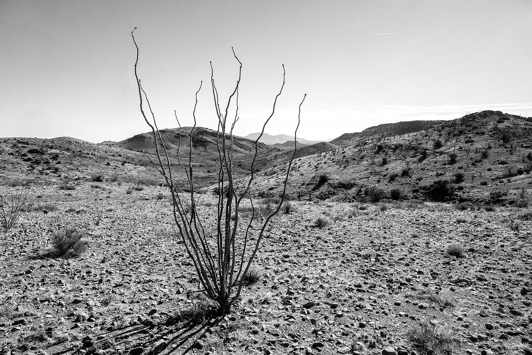
Ocotillo on Massacre Peak in the southern part of the Cooke's Range. 
(Click images to view larger)

Cooke’s Peak rises 2,400 feet above the remote trailhead where seven of us (and three dogs) gathered on a chilly January day for a long-anticipated hike to the top. The route climbs an alluvial fan and turns into OK Canyon where it winds through oak, sotol, and juniper before launching steeply upwards over two saddles to a short third-class summit scramble. We hoisted our daypacks and set off up the trail while the dogs ran around finding old bones and muddy puddles, covering at least twice the distance we did during an already long day.

Cooke's Peak (the pointy one) viewed from Mimbres Valley northwest of the range.

On the trail to Cooke's Peak with the Chihuahuan Desert far below.

The view east from near the summit of Cooke's Peak.


The peak dominates the northern end of the Cooke’s Range, one of many obscure “sky islands” rising from the desert basins of Southern New Mexico. Thanks to a perennial spring, it played a disproportionate role in U.S. and Mexican history and the U.S. doctrine of manifest destiny. Military, mail, and passenger routes between the East and California stopped at Cooke’s spring rather than bypassing the mountains because it offered the only reliable water between the Rio Grande and the Mimbres River. 


A lone ocotillo on Massacre Peak in the southern Cooke's Range with the Florida Mountains in the distant background. The easiest  east-west route is between the Floridas and the Cooke's Range, but there isn't any water.


Lt. Col. Philip St. George Cooke traveled the route in 1846-47 with a ragtag battalion of Mormon “soldiers” recruited in Iowa to bolster the U.S. military presence in the southwest, much of which was still owned by Mexico, and to diffuse tensions with the Mormons. They welcomed this because it gave them a chance to travel west funded by the military, escaping persecution in Iowa. After prolonged conflict and negotiation with Mexico, the Gadsen Treaty established the international border about where it is today, and the U.S. gained possession of Cooke's route.


Ellen near the summit of Massacre Peak just south of Cooke's Gap and west of the spring. A plaque commemorated the Cooke expedition as well as a group of boy scouts who visited the summit more recently, presumably to install the plaque.


Long before Europeans started arguing over ownership, the Mimbres chipped petroglyphs in the hills and canyons of the range. They are often fantastical, though some depict easily recognized rattlesnakes, sheep, bear prints, and yuccas. There are even the outlines of scarlet macaws on boulders in at least two sites. These tropical birds were traded (and maybe bred?) as far north as Chaco Canyon and its outliers and clearly had religious and cultural significance. Their feathers have been found attached to prayer sticks and ceremonial clothing. The Mimbres abandoned the area around 1150 AD, perhaps migrating south into Mexico. Bands of Apaches later established ephemeral camps in and around the Cooke's Range where they hunted and organized raids.


Petroglyphs in the Cooke's Range.

More petroglyphs including a possible macaw and Santa Claus roasting a dead rat over a fire??!!

Grinding holes in sandstone.
 

The Apaches were antagonized by the stream of Europeans threatening their sovereignty. Cooke’s Pass, just west of the spring and sandwiched between steep cliffs and hills for over a mile, was a perfect place to attack travelers, and the Apaches took full advantage. During one well-known attack in July of 1861, Mangas Coloradas and Cochise, two famous Apache leaders, ambushed seven members of the Freeman Thomas Mail Party as they entered the canyon, forcing them up a side canyon to the south where they built rudimentary rock shelters and fought the warriors until their inevitable deaths. According to an account by Jay Sharp, the stripped and mutilated bodies of Thomas and his companions were found two days later by passing freighters who described the scene:


The ferocity of the battle, the freighters said, could be measured by the numerous shell casings littering the ground and the bullet marks covering the rocks and trees around the stone barricades.”  


Ellen hiking through Cooke's Pass in November and feeling somewhat less terrified than travelers 150 years earlier, despite the 8-mile shadeless round-trip. 

We spent a day trying to find the site of this attack, but aside from a few ambiguous rock shelters, any signs of the battle have been erased by 160 years of weather and scavenging. This and many other attacks led to the construction of Fort Cummings near the spring in 1863 and deployment of military personnel to protect the vital transportation route. Today, all that remains of the fort are a few decaying adobe walls and a barren cemetery. 


Decaying adobe walls at Ft. Cummings, once a busy military outpost positioned to protect travelers from Apache attacks.
 
Lonely graves at the Ft. Cummings cemetery. The military was tasked with collecting human remains that had been left scattered along the route through Cooke's Pass and relocating them to this cemetery. The bones and bodies contributed to the terror travelers felt as they passed through the canyon.

After the Indian Wars, the Cooke’s Range was occupied by miners, goat herders, and ranchers. Abandoned towns dot the foothills today, and old mines are everywhere. To the west, Flourite Ridge is riddled with adits where miners extracted its namesake mineral, used to make steel, especially during WWII. Also during WWII, in the basin to the east, pilots dropped bombs containing small amounts of explosive and a lot of flour to mark the spots where they exploded, helping them evaluate their aim.


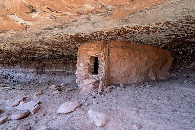
A stone house probably used by miners near the north end of Fluorite Ridge.

On the northeast flanks of the range, the once prosperous mining town of Cooks Town (spelled without the “e”) is mostly gone save for remnants of a few buildings. The town was established in 1876 and mostly abandoned by the beginning of WWII but it once had as many as sixteen saloons (and no churches!). Donald Couchman (Couchman 1990), in his comprehensive Master’s thesis on the history of the region, tells a story of intrepid partiers from Cooks Town: 

Many of the community social functions were conducted at the schoolhouse…People would come from as far away as Deming, Lake Valley, Las Cruces, Hatch, Hatchita, and the settlements along the Mimbres River. The revelers pushed the school furniture against the wall for room to dance and used the seats for beds for the children when they could no longer stay awake…Sometimes after dancing all night, the participants would climb the remaining distance to Cooke’s Peak and enjoy the dawning of a new day together. 

We stopped for a snack below the summit headwall and then scrambled to the top where a little snow and rime from the previous night’s storm clung to rock and a few hardy desert plants. To the south, the craggy Florida (pronounced Flor-eed-ah)  and Tres Hermanas Mountains rose behind the town of Deming; to the west the Big Burro Mountains and Apache Peak guarded the New Mexico-Arizona border; sixty miles to the east, the Organ Mountains stood behind Las Cruces; and to the north lay Silver City and the vast Gila National Forest. A lot had happened in the country visible from the peak since humans found their way into the southwest. A little reluctantly, we started down, tired from the hike even without having danced all night.  


Ellen and our friend, Beth, at the summit of Cooke's Peak.

Carlos, Beth, and Ellen, starting the descent from the summit.

A last view to the east during the descent back to the trailhead.


Proposed Mimbres Peaks National Monument


Along with the Floridas, the Tres Hermanas, and the Goodsight Mountains, the Cooke’s Range is included in a proposed Mimbres Peaks National Monument, which would include just over 245,000 acres. Together, these sky islands account for remarkable biological diversity, numerous cultural sites, and unlimited opportunities for adventure. 


References


Barbour, Matthew J. 2014. Journey Through the Mining Camps of Cookes Peak in New Mexico Where Mineral Riches Once Thrived. Miningconnection.com.


Couchman, Donald Howard. 1990. Cooke’s Peak – Pasaron Por Aqui. A Focus on United States History in Southwestern New Mexico. Cultural Resources No. 7. Bureau of Land Management, Las Cruces, New Mexico.


Sharp, Jay. Cooke’s Canyon. Journey of Death. DesertUSA.com.

Tuesday, February 1, 2022

Backpacking in Grand Gulch: Collins Spring to Kane Gulch


Scott Lehman at one of my favorite petroglyph panels.
(Click on images to view larger)

When I first visited Cedar Mesa in the 1980s, Grand Gulch was obscure, with word-of-mouth descriptions of arduous bushwacking and secret ruins. Since then, guidebooks have been published, books written, and the Bears Ears National Monument created, diminished, and finally restored, hopefully forever. A growing number of people hike regularly in the Gulch and its tributaries, and it seems that everyone has a secret undisclosed discovery, enticing the rest of us to keep looking. Despite growing popularity, it remains one of my favorite places; no one will ever peer into every hidden alcove or look behind every exfoliated boulder to find the last undiscovered treasure, and even without its cultural heritage, Grand Gulch is stunning. 


In March of 2021, I spent a week with Ellen and our friends, Scott and Bay, hiking from Collins Spring to Kane Gulch, about 38 miles. We’d all walked much of this section and many of its side canyons before but in pieces on many trips over many years, so it was fun to traverse it in one hike. 


While the walking was easy (we planned short days to leave time for ruins and rock art), the drought presented challenges. Water in much of the canyon had disappeared, and hikers, us included, planned our days and camps around what little water could be found, some barely drinkable even with filtering. I recently wrote about climate migrations in the Southwest, partly stimulated by this experience of traversing the canyon in a dry year. Until about 700 years ago, it supported a thriving Ancestral Puebloan community. The gist of that post was that drought destabilized their society, leading to abandonment. 


While on this hike, I realized that drought need not be long-term to drive people out. After a few years without good monsoon rains or winter snow, most of the water was gone. How long could permanent residents of Cedar Mesa live and farm without regular rain? A few years? A decade? How much water could they store from ephemeral summer showers or winter snow? Are there enough obscure springs to sustain a substantial population through several dry years? I don’t know the answers to these questions, but when we were in the canyon in March, there was barely water to support a few dozen backpackers on their vacations, passing through the canyon for only a few days. 


These are a few pictures from our trip. Except for some of the well-known sites, I don't specify locations.


Ellen and Bay (not Bei, our daughter!) enjoying pictographs in a Rincon north of the junction of Grand Gulch and Collins Spring.

The Bannister Ruin. We camped near here on the first night. Bannister spring was dry (we carried water from the trailhead) but I scrambled to a pothole above the canyon floor that was filled with good water.

An arrowhead found in the wash and returned to it after being admired. I recommend Craig Child's book, "Finders, Keepers" for those of you interested in respecting archeological finds.

Handprints.

Routefinding is not too tough when you are following a major canyon, but keeping track of side canyons requires some attention.

A small man (me), and woman (Ellen) sit below the Big Man Panel north of Polly's Canyon. 

More handprints. Bay recreates the moment.

An intact granary tucked beneath a reticulated roof.

The bird panel. I carried my lightweight backpacking camera without a very long lens, and these were high above the canyon floor, but you can zoom in to see better. The pictographs are exquisitely detailed. 

Ellen and Bay scrambling to see a ruin and rock art in a side canyon.

Bay (left) and Ellen enjoying rock art.

The breech birth panel. 

Our camp on a ledge above Coyote Canyon. The spring in the canyon bottom produced good water.

A potsherd inside a ruin.

A wall tucked behind a fallen boulder, with pictographs lined up under the arch behind it.

Bay admiring a petroglyph panel at the mouth of Todie Canyon.

After the hike. Left to right: Bay Roberts, Scott Lehman, Ellen Axtmann, and me.

Water info: Grand Gulch was very dry after a multi-year drought and the failure of the monsoon the previous summer. We found water in a pothole (ephemeral) at our first camp near the Banister ruin on a slickrock shelf that required scrambling to access. There was water in lower Collins Canyon and for short way up Grand Gulch from the confluence, and again in pools in the main Gulch just downcanyon from Polly's. Water was available a short way up Green Canyon and farther along in Green Mask Canyon below the well-known rock art site. The Coyote Canyon spring was running. Farther up, we filtered nasty water from a pool under a pouroff down canyon from the mouth of Todie Canyon. We were told that there was water up Todie in the North Fork, but we used our filtered water instead. From there, we walked out to Kane Gulch. 

Don't rely on the BLM office in Monticello, though they may have some information. If the Kane Gulch Ranger Station is open, it’s a more reliable source of information. Of course, there can be much more or much less (!) water depending on the year. 

Another much more detailed blog post on this hike going in the other direction is at this link and there are many other detailed accounts online if you search for them.