
Looking out over the first part of the smoky, hot (90s) White Rim from the Shafer Overlook.
(Click images to view larger)
On the first of three nights spent on the White Rim Trail we camped at the exposed Airport site, and after dinner, the 90+ degree cloudless day gave way to violent wind and lightning. We did our best to hold our tents together. I plastered myself against the windward wall of our Big Agnes Copper Spur 2, while Ellen lay on her back supporting the poles with her feet and the opposite wall with her arms. One pole snapped and ripped through the fly, but we stayed mostly dry even as blowing sand filtered through netting onto our pillows and sleeping bags. After more than an hour of wind (60 mph? 70mph? more?) and just enough rain and hail to turn the dust to mud, the storm moved on, and we reunited in the dark with our friends to assess the damage, comb the desert downwind of camp for lost crap, and compare stories. Despite the violent storm, it never got even remotely cool.
The trip included eight of us from all over the West (Laramie, Boulder, Ft. Collins, Bisbee, Seattle). We mountain biked the route over four days in mid-September, when temperatures each day hovered in the 90s and low 100s, well above "normal" for that time of year, but not that unusual either. 90s and 100s are less ideal than other temperatures, but despite the heat and wildfire smoke, it was a very fun trip--much more fun, for example, than the plethora of pandemic-spawned Zoom meetings (graphic below) all of us have faced.
The world has changed since the last time I was on the White Rim decades ago. Mountain biking wasn't even a thing then, when, with no permit required, friends and I camped for a week in Taylor Canyon to climb Moses and Zeus (sandstone spires) and didn't see another soul. Moab, then relatively sleepy, is now a hellscape of ATVs, traffic, tourists, hotels, restaurants, and t-shirt stores; it's hotter and smokier in the West every year; covid rages; and mountain bikers (including us) are everywhere. Despite that, the White Rim remains beautiful and uncrowded. What a pleasure, even in the heat, to ride with good friends along the Colorado and Green Rivers, past Wingate cliffs with spires coming into view around every corner and good meals at every camp.
Here are a few photos from our trip, and a little information follows on logistics.

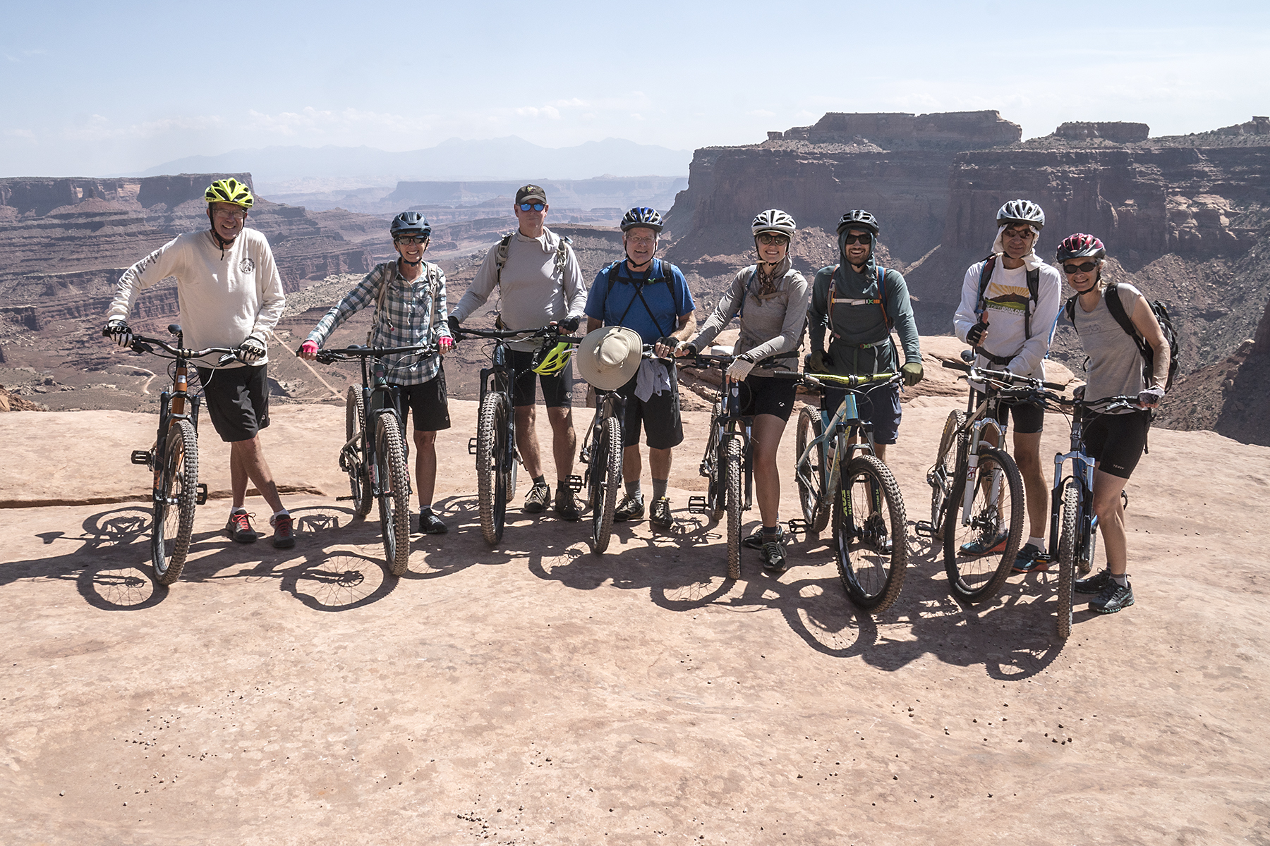
(L to R): Me, Ellen, Brian Collins, Larry Scritchfield, Allie Ruckman, Ben Leonard, Bret Ruckman, Judy Ruckman. We were barely sweating at all before we started riding.

Shafer Overlook: Larry looking down at the Shafer switchbacks--the descent route to the White Rim.

Day 1: Bret pointing out Crow's Head Spire, a climbing destination. We camped on the rim near there after finishing the 4-day ride.

Day 1: White Rim sandstone capping mini-spires along the rim.

Day 1: Musselman Arch. Walking across it is prohibited, but rumor has it that it's been traversed by ATVs (and probably motorcycles).

Day 1: One of many enticing canyons cut into the White Rim. The heat kept us from getting too enticed though.

Camp 1: Not so ominous (we thought) storm clouds gather near our first camp at the exposed Airport site. After we retired for the night, the storm unleashed 60-70 mph wind and rain, hail, and lightning for over an hour, during which we all fought private battles to keep our tents from being tattered and rolled across the desert. It was engaging and amusing.

Camp 1: Larry (R) and Brian (L) set up their tents at the Airport site. Unlike some of us, they had the wisdom to attach their tent flies BEFORE the wind reached tropical storm force.

Camp 1 (morning): The next morning, Ellen (L) and Judy (R) compare notes on how to hold a tent up with your feet in 60+ mph wind.


Day 2: Bret riding with Monster and Washer Woman Towers in the background.

Day 2: Allie and Judy share the shade of an umbrella. My umbrella self-destructed at our first rest stop on day 1 ($5.99 just doesn't buy the quality it used to), so I was left with only my hat for shade.

Day 2: Bret standing on the rim of an enormous alcove undercutting the road/trail.

Day 2: 90s? 100s? Shade?

Day 2: Ellen approaching the steep climb to Murphy's Hogback near the end of the second day of riding.

Danny McGee, our sag driver. He works occasionally for Rim Tours, a Moab outfitter. Rim Tours was great to work with, and Danny was incredibly accommodating and patient as we wobbled along in the heat. He's a climber and knew Bret from Boulder, so there was an immediate connection.

Camp 2 - Murphy Hogback: We camped on top of the Murphy Hogback after walking our bikes up the steep hill that leads up it. We enjoyed great views from the camp and no more storms.

Camp 2: Bret organizing his and Judy's tent on Murphy's Hogback as the sun set.

Day 3: Watching freshwater shrimp in a pothole at Black Crack. Black Crack is a deep fissure that runs parallel to the rim for hundreds of meters where a part of the White Rim sandstone is separating from the rim.

Day 3: Brian taking refuge in a rare spot of shade on a day when a passing 4WD group told us it was 103 degrees.

Day 3: Lunchtime in the shade where the trail crosses the Holeman Slot. After lunch, we descended partway down the slot, which was shady and full of pools of water.

Day 3: Bret spotting Judy on a downclimb in the slot. With muddy feet, The slab below him was the crux of the climb out on our return.

Day 3: Fixing a flat tire in the shadeless desert.

Camp 3: Sundown at Hardscrabble Bottom on the Green River, our last camp. After a day of riding in 100+ degree blazing sun, we lowered our body temperatures in the Green River and sat in the shade of an awning drinking beer.

Camp 3: Bret with bacon! Breakfast on our last day.

Day 4: Sunrise. Hardscrabble Bottom.

Day 4: Allie and Ben ride along the Green with youthful enthusiasm on the last day. Morning shade made youthful and oldful enthusiasm more achievable.

Day 4: Back to the car shuttle at the top of Mineral Bottom.

Camp -- post trip: Crow's Head Spire from the rim (see earlier picture). Ellen and I camped with Bret, Judy, Allie, and Ben near here before we all headed off in different directions.
Logistics
We rode from Shafer to Mineral Bottom, which seemed good, but people ride the other way too.
There's no shortage of information online about the White Rim (see links below). The challenge is reserving well-spaced campsites along the way; our strategy was for 3 of us to hover over our keyboards on the day they opened up reservations for the time slot we wanted. The camps we got (Airport, Murphy's Hogback, Hardscrabble) were pretty good--Murphy's was great. White Crack seems to be the camp everyone wants to get, but we weren’t fast or lucky enough to grab it.
We paid Rim Tours to sag our trip so that all of us could ride every day and to save our own vehicles from the rough road. Most of the road was good, but the climbs up Murphy’s Hogback and Hardscrabble Hill seemed a little gnarly, and there were some deep mud holes on the last day. Presumably, the road gets graded now and then (??), but I was glad we didn’t drive it ourselves.
We bought food as a group and took turns cooking and cleaning up. That worked well on our trip, but required a lot of planning with a big group. The alternative would be for everyone to buy their own food and cook for themselves. That choice is just a matter of group preference.
See the following for more info:


