Saturday, February 6, 2016

Horizon Lines: Namibia

Rest area between Uis and Henties Bay, Namibia.
(Click images to view larger)

Pat Kikut, a lecturer for the University of Wyoming Art Department, presented at the first Geography seminar of the spring on his project exploring the high points of Texas, Oklahoma, Kansas, Nebraska, and the Dakotas. As you might imagine, some of these aren’t much higher than the grasslands spreading out from them in all directions, and much of the fun of the project appeared to be in finding these topographic crests, camping near them in a vintage trailer, and wandering around the High Plains on long summer road trips. 

One result was a series of simple paintings where horizon lines, defined by distant patches of trees or human detritus, divided the canvas into sky and prairie.  Kikut said in his seminar that he experimented with how a few dabs of paint along the horizon line in a 30” x 60” canvas can define so much space. 

In the press release for a showing of the work at the Ucross Foundation near Sheridan, Kikut said:

“Western landscape painters have mostly ignored the High Plains…These landscapes often appear to me like empty stages where the actors have abandoned their spots on the stage and left the props of their actions strewn about the landscape/stage. They are powerful to witness as they often reflect an interesting interaction between our encroaching culture and the unpredictable forces of nature.”

The same might also be true of photographers, although there are more of us, many of whom live in these landscapes.  

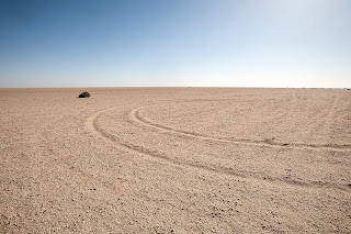
Namibia is a long way from the U.S. High Plains, but Kikut’s artwork and photographs reminded me of trying to capture images of the often unbroken starkness of the Namib Desert, so I’m posting some from there, most taken at the end of my own 2014 road trip, after I had hiked across the Brandberg Mountains. 

My not rugged rental car, Namibia.

Springbok.

Spitzkoppen Mountains, Namibia (there's rock climbing there!).

Closer view:  Namib Desert rest area with Brandberg Mountains in the distance.

Pole, Namib Desert.

Shrub with tire tracks.

Shrub without tire tracks.

Powerline leading to the Atlantic Ocean.

Salt for sale.

Railroad crossing near Swakopmund.

Railroad near Swakopmund.

Monday, January 18, 2016

Uinta County, Wyoming

An abandoned gas station along I-80 near Lyman, in Uinta County, Wyoming.
(Click images to view larger)

Interstate 80 between Rock Springs and Salt Lake City divides Wyoming’s Uinta County into two landscapes. North of the highway are dry rolling shrublands interrupted by a few small towns, while to the south, complicated badlands erode into rivers, including the Bear and the Black’s Fork, that flow out of the Uinta Mountains of Utah. I’ve spent little time exploring this part of Wyoming, but last fall Ed Sherline and I headed there for a weekend in hopes of answering a call for a photo of Uinta County as part of the art to be installed in the remodeled gymnasium at the University of Wyoming. We spent most of our time south of I-80 in the badlands, but also enjoyed exploring towns along and north of the interstate, which used to be the iconic Lincoln Highway.

Here are a few pictures from the weekend, including a few from southern Sweetwater County to the east. 

Flaming Gorge, in Sweetwater County, viewed from the west.  

The Black's Fork River, brought to its knees by the depleted Flaming Gorge Reservoir.

The zone of intermingling between what was once the Black's Fork River and what is now Flaming Gorge Reservoir in Sweetwater County.

Looking southwest across the Black's Fork valley from our camp in badlands near Cedar Mountain.

Eroding badlands between Lyman and the Black's Fork.

Rabbitbrush along the Black's Fork River.

A window in the abandoned general store at Carter, Wyoming, named for the prominent Judge,  William A. Carter, who lived in nearby Fort Bridger from 1859 until he died in 1881.  

An ad hoc sculpture, seen through a window in an abandoned bar at Carter.  

Building decoration, Carter, Wyoming.

There's a fine line between Evanston, Wyoming, and the surrounding shrublands.

An old train platform in an industrial area at the north end of Evanston.

Xotic fireworks, Evanston, Wyoming.

An abandoned house at the ghost town of Piedmont, Wyoming.  The town was originally a logging camp supplying railroad ties for the Union Pacific Railroad in the 1800s and later charcoal for iron smelting in Salt Lake City.

Graffiti in an abandoned house.  Piedmont, Wyoming.


Charcoal making kilns.  Piedmont, Wyoming.