
Death Valley is famously hot, dry, and barren, but cold temperatures, flooding, and bushwacking posed challenges during a short visit in January 2023. The park is nothing if not diverse, with elevations ranging from 292 feet below sea level in Badwater Basin to over 11,000’ at the summit of Telescope Peak, so it's not surprising that conditions don't always match the cliches. When I met Larry Scritchfield for a little mid-winter backpacking (and to escape the relentless Wyoming cold), high temperatures averaged around 60 in the basins, way warmer than the surrounding mountains where we hiked, many blanketed with snow.


We’d also hoped to get a taste of Death Valley canyoneering, known for rappels off carefully constructed rock piles (sketchy??), but our canyon partner, Don Reyes, who lives near Lake Tahoe, was digging his renters out of serial Sierra snowstorms and had to bail at the last minute. Canyoneering is collaborative--more fun and safer with three than two, so we postponed those plans.

Larry and I rendezvoused at Stovepipe Wells, just below sea level, where a friendly hotel (showers for $5!) and restaurant on one side of Hwy. 190 face a campground and store on the other. The campground, mostly empty in January, is a gravel parking lot with carbonite posts marking sites, devoid even of picnic tables. We parked on one edge of the lot, giving us access to the empty desert for late-night peeing. Not far to the east, the Mesquite Dunes spawned plumes of dust that thankfully blew away from the campground on frequent windy days. To the west, the Cottonwood Mountains, part of the Panamint Range, where we planned to hike, dominated the skyline, their highest peaks dusted with snow.

Flash floods during the August (2022) monsoon washed out many roads in the park, including access to popular tourist spots (Scotty’s Castle, the Racetrack, etc.), and a smaller rain event just before we arrived turned the road to the 28-mile Cottonwood-Marble Canyon loop, our main backpacking objective, into a quagmire. An apologetic ranger at the small Stovepipe Wells station where we stopped to collect our free permit delivered the bad news, squashing our plan to start the 4-day hike that morning. Instead, we regrouped and headed for Indian Pass in the Funeral Mountains on the eastern edge of the park, an overnight out-and-back that included a 4-mile slog up an alluvial fan (fanyoneering?), while we waited for the Cottonwood Canyon road to dry out.


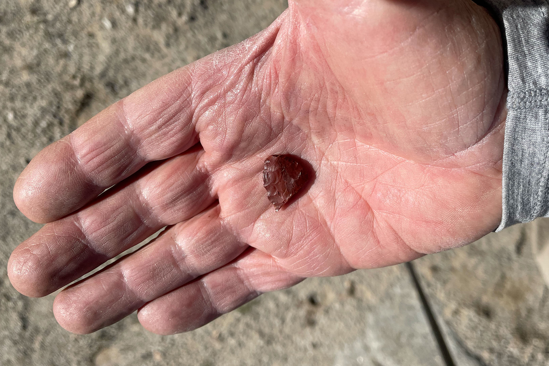
Later in the week, after the overnight and two day-hikes, we finally started the loop, which climbs gently up Cottonwood Canyon, then north up a swale to eventually cross a saddle before descending steeply into Deadhorse Canyon which drains into Marble Canyon, itself descending through spectacular narrows back to the trailhead. Along the way we enjoyed impossibly complex geology, petroglyphs (spaceships??), wild horses, freeze-dried lasagna, and perfect but freezing campsites.
I seldom move much before finishing my morning coffee, and pre-caffeine I don’t even like to be asked about what I might do later in a day. But in one of the hottest places on the planet, it was so cold (and windy) at our first two camps that Larry and I crammed our gear into our packs at dawn and walked until we could find sunshine and a little warmth before brewing freeze-dried Via “coffee” packets and eating breakfast. Probably in the low to mid-20s at night, desert cold always feels colder than mountain cold. I hiked those mornings in the winter clothes (hat, gloves, long underwear, puffy) that I wear Nordic skiing at 9000’ in sub-arctic Laramie, Wyoming and still didn't feel quite warm.


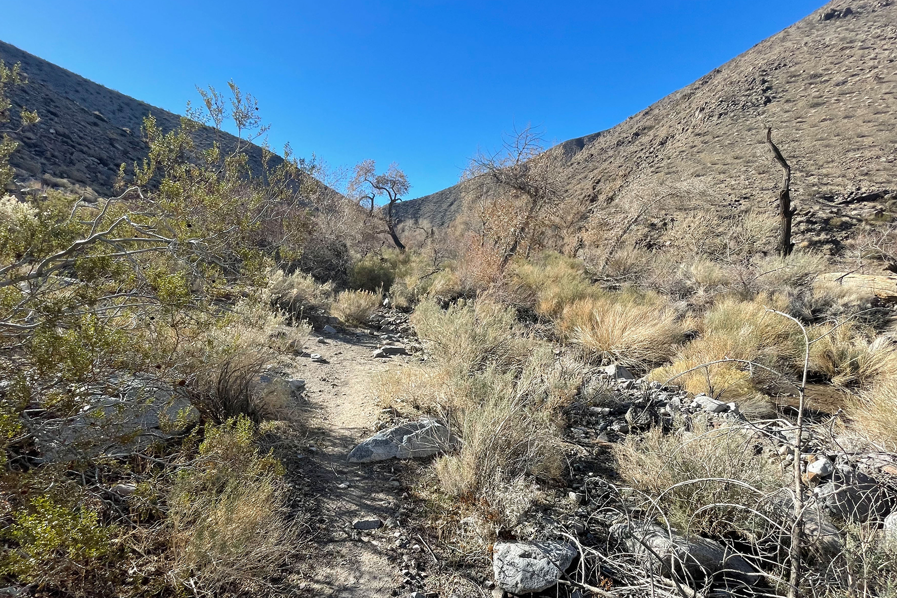
Another ironic challenge on the hike was vegetation. We joked about bushwacking on the Indian Pass hike whenever we passed close to an infrequent creosote bush. How naïve we were! In Cottonwood Canyon and to a lesser degree in Dead Horse Canyon, what little vegetation there was packed itself into the V-shaped drainages where the few springs provided enough water for trees, choking the canyon with an impassable tangle of downed cottonwood limbs, fallen trunks, and impenetrable shrubs, some thorny, forcing us up onto steep, loose, sidehills above the drainage, sometimes exposed enough to drive us reluctantly back down to bushwack hopelessly until we could find another escape. Short distances near these “oases” took longer to traverse than miles of open desert.
Death Valley is a vast park, too hot most of the year for much activity, but a refuge in winter. From salt flats, dunes, and badlands to mountains harboring ancient but threatened bristlecone pines there’s enormous diversity. And despite the harshness, humans have left their mark with old mines, ghost towns, and remnants of a once thriving borax industry (20-mule trains!). It attracts desert rats and misfits as well as cyclists, outdoor adventurers, and retirees. I find myself there once in a while, and though I often wonder if I’ll return, each trip leaves me curious about just one more thing that I’d like to check out.

Wonderful trip report! Brought back memories of those cold but beautiful camps. (We had snow flurries our first night and temps in the teens on our second.) Your photos do justice to the diversity of Death Valley. BTW, how did you deal with that little boulder problem downclimb below the spring in Deadhorse Canyon? I confess I carried a handline and left it in place for my non-climbing partner.
ReplyDeleteThanks Darrow. The camps were perfect on that flat coarse sand with big boulders to sit on. That pourover was running with a waterfall, so we found an easy way around it! It would have been an unpleasant down climb in the water! Great that you did that hike.
ReplyDeleteAfter telling you I needed a dose of adventure pics, I had the brilliant idea to come back here. Death Valley was a favorite right up to moving to Jackson. A wild and sublime place. And Huge. Great images. I do remember those special winter chills.
ReplyDeleteHi Jim--yes, it's a huge and compelling place. It would be great to thread the needle sometime between the chill of winter and the furnace of summer.
Delete