Sunday, May 25, 2014

Quick Post: Uganda

A young girl at the Kukanga School

I'm in Kampala using very slow internet, so I'm going to try to post up a few pictures and will post more extensively sometime when I get a faster connection--maybe from Namibia.  I've been visiting schools for One School at a Time.  You can google their blog to see more info!  Cheers from the equator.

Students at the Bbinikila School.

Girl with headscarf, Kassanda Boarding Primary School.

Girls, Kukanga School.


Wednesday, May 14, 2014

Heading Out: Uganda and Namibia

Street scene:  Kampala Uganda.  2009

On Friday I head to Africa for a month!  

After hopping from Denver to Chicago to Brussels, I arrive in Kampala, Uganda on Saturday.  As I watch the last of Laramie's most recent (May) snowstorm melt away, equatorial Africa sounds increasingly appealing.  

The first two weeks will be spent with Hussein Tadesse, working for One School at a Time.  Hussein is One School's in-country program manager, and I'll stay at his house along with his wife and five (!!) kids.  I'm on One School's board.  

I was last in Uganda in 2009 mostly to take photos for One School, and much of my time was spent at rural schools photographing and visiting with the kids.  It will be fun to see them again.  This time I'll split my time between Kampala and rural schools, and I'll be shooting photos, helping with  administrative work, and, for the first time, trying to capture reasonable video.  That last task is a tall order, since I haven't shot video before except for jiggly footage of Bei's choir and skating events, and it will be fun to see what I can come up with.  My mantra for video is "don't move the camera," and I intend to leave it firmly planted on a tripod while in video mode.  I'm not quite sure how to balance collection of video and stills with meetings in which I'm a participant, but at least I won't be bored.  

After two weeks in Uganda, I fly to Windhoek, Namibia to hike to the top of the Konigstein in the Brandberg Massif, and then to spend the remaining few days of my trip driving down the Skeleton Coast and on to wherever the wind blows me.  The Brandberg is famous for its San pictographs, and I'll hike for 4-5 days to see rock art sites amongst the granite boulders and dry peaks.  

I hope to post blog entries while on the road, but internet in Kampala is sketchy and time will be short.  I'll see what I can do.  At the very least, I'll have some good stories to tell when I return.  

Hopefully by then (mid-June), it will be summer in Laramie.  Stay warm.

Hussein Tadesse, my host while I'm in Uganda.  

Joel, whose house I stayed in in 2009 near the rural schools I worked with.  Joel owns a private school funded in part by his pineapple farm.

Mikey, at Joel's house in 2009, enjoying one of my cameras.


Soccer with a homemade ball.  I'm carrying an indestructible soccer ball with me to Uganda to give away.

A school for orphans near the source of the Nile that I visited in 2009.  One task will be meeting with potential new partner schools.  

Downtown Kampala.  2009.

Tuesday, April 15, 2014

Spring Break 2014: Fence Canyon to Harris Wash, Utah

Ellen and Bei exiting Harris Wash on slickrock at the end of our hike.


I remember how excited I was about backpacking as a youngster growing up in the Virginia suburbs of Washington D.C.  I went on trips with my scout troop, which was remarkably active, and before very long I was hiking with friends and even alone.  In retrospect, it seems incredible (but great) that my parents let me out for a week by myself when I was not much older than Bei, now 12.  Once, in the mid-70s not long after the Watergate scandal, I hiked alone on the Appalachian Trail for a week, carrying a very lightweight, bright yellow, aluminum frame pack, covering 10-20 miles a day, and then settling into camp to read Woodward and Bernstein’s book, All the President’s Men.

Early in my backpacking career my parents gave me a SVEA 123 stove, a Swedish contraption, heavy but functional.  It looked like a shiny perforated brass cylinder with a windscreen, also brass, that twisted off and on, unlike today’s lightweight aluminum foil windscreens that fold up to be inelegantly stuffed into a sack.  I loved the whole idea of that stove and everything about backpacking. I devoured Colin Fletcher’s The Complete Walker but lingered over his advice about how to traverse the backcountry more effectively. I told friends how great it was to be so untethered, with everything you needed right on your back(!!).

Later, when I became a rock climber, backpacking became an unpleasant means to an end—the painful part of getting to a remote climb, less enjoyable than in my youth, in no small part because of the weight of rope and gear and the need to go fast when big climbs were squeezed into weekends. I scoffed at backpacking for its own sake, wondering why anyone would carry all of that weight around without the reward of a wilderness climb at the end of the trek.

Now, at age 55, backpacking is regaining its appeal.  I’m less ambitious, and it’s just nice to be out.  And I have enough money to invest in ultralight gear, the newest thing. Sleeping bags are no longer giant and heavy. Tents are wispy. Empty packs don’t weigh 10 pounds. I can walk with my family and enjoy not carrying 30 pounds of climbing gear.  And I’m not in a hurry. I’m not so fascinated by the gear anymore, and I like relaxing and exploring. Plus, I’m not nearly as hungry as I was when I was a teenager, so food doesn’t weigh so heavily on my mind when I have only a limited amount. 

For our spring break this year, Ellen, Bei, and I walked a lovely loop in the Escalante drainage of SW Utah.  We left our car at the Egypt trailhead, hiked down to the Escalante river, and explored downstream to Neon Canyon and the Golden Cathedral before carrying our nice little ultralight loads upstream to Harris Wash.  Eventually, we scrambled out of Harris on slabs (scary for Bei) and returned to our truck. Along the way, we camped in perfect spots—at the mouth of Fence Canyon where a clear spring kept my half-and-half cold long enough to enjoy a few cups of creamy coffee before switching to powdered milk; at the mouth of Choprock Canyon where moqui steps provided an unlikely path to the canyon rim; at the mouth of Harris Wash where a perfect sandy bench allowed me to be barefoot while my shoes dried after multiple river crossings; and finally, on slickrock above Harris Wash where we enjoyed a little campfire under a full moon. 

Bei doesn’t share my love of being out, and she would never admit it even if she did have fun with a pack on her back, but  I think she enjoyed the trip despite herself, and it was more fun goofing around with her in camp than trying to compete with electronics at home. I’m grateful that when I was her age, compact little brass stoves were the most exciting thing around. But I’m also grateful that I can spend a week with Bei and Ellen wading across rivers, gnawing on bagels, bushwhacking through tamarisk, and reading by headlamp in our cozy little tent.

Ellen and Bei, hiking off of the Egypt Plateau towards Fence Canyon and the Escalante River.

Descending into Fence Canyon.

Bei, sleeping late in Fence Canyon.

Heading for Neon and wading the Escalante.

One day we crossed the river 14 times.

Petroglyphs and cowboy graffiti near Neon Canyon.

Bei leaving the Golden Cathedral in Neon.

Mud flakes near the mouth of Neon.

Bei and tamarisk, along the Escalante.

A gift to me from Ellen--an ultralight coffee filter.  At the mouth of Choprock Canyon.

Lunch between Choprock and Harris.

Lower Harris Wash.

Moqui steps near the climb-out from lower Harris.  There is an easier exit a little farther upstream

Me and Bei after the exit climb.

Ellen and Bei at our slickrock camp above Harris Wash.

A campfire (later erased!) on the slickrock.

Saturday, January 25, 2014

Ephemeral towns around Wyoming's Great Divide Basin

The view east from Bairoil, Wyoming.  
(Click images to view larger)

Through history people have lived around the margins of endorheic basins.  Some are filled with water, like the Aral Sea in Central Asia, while others are seas of dunes, like the Tarim Basin in Western China, once an obstacle that split the Silk Road into two routes to avoid the Taklimakan Desert (rough English translation:  If you go in, you won't come out), that occupies its interior.  The Taklimakan is so dry that natural mummies, so well preserved despite their 3000+ years that you can look into their faces and imagine them alive, sometimes emerge from the sand.  Some have red hair and blue eyes, immigrants to China from Europe. 

Tuyuguo, a still-occupied town on the margin of the Taklimakan Desert.

Endorheic is a technical term that describes places with no external drainage—rain that falls in these basins doesn’t find its way to the ocean, instead evaporating in place or seeping into groundwater.  Death Valley, famously hot and below sea level is endorheic.   

Wyoming’s Great Divide Basin (GDB), another endorheic basin, is not so well known or so well protected, and many people don’t know that the Continental Divide splits around it after descending from the Wind River Mountains to its north.  In all, it occupies about 3,900 square miles of mostly BLM land, with significant areas owned by ranchers, leased by energy companies, or occupied eccentrically (or creepily if that’s a word) by a handful of desert dwellers. 

Were it not for energy extraction, there would be little reason for most people to live near this harsh place.  It shares Wyoming’s howling wind and frigid winter with the rest of the State, but none of its spectacular mountains, though the Ferris, Green, and Wind River ranges are visible from within.  Around the margins are ephemeral towns that come and go with the fickle energy market:  Wamsutter, Lamont, Bairoil, and Jeffrey City.  A few larger and more permanent towns occupy sites along the Union Pacific Railroad to the basin's south:  Rawlins and Rock Springs are the largest.

I’ve photographed in and around the GDB for years, usually drawn to abandoned houses in the interior or wild horses that live there, or to desert places like the Honeycomb Buttes, but in January Ed Sherline and I left Laramie to have a look at some of these towns, each with its own character, and all temporary.  I doubt that any have the staying power of China’s Silk Road towns, still present all of these thousands of years after they were established. 

Jeffrey City is perhaps the most “famous” of the GDB towns among ghost town aficionados and in the boom-bust history of the West, though it isn’t truly a ghost town;  50-100 people still live here. In summer, cross-country cyclists stop for a meal and a place to sleep after pedaling across this particularly empty stretch of Wyoming.  In winter, snow drifts into abandoned townhouses and dormitories built to house workers during the uranium boom in the late 1970s.  A church, a bar, and a potter's shop are still used, but most other businesses as well as a modern brick building housing and Olympic-sized swimming pool are closed up tight.  

Bachelor Apartment #2.  Jeffrey City, Wyoming.
   
 Named “Home on the Range” by its first homesteaders in the 1930s, the town was renamed in the late 1950s for C.W. Jeffrey, a Rawlins doctor who financed a plan to extract uranium from nearby deposits to fuel nuclear power plants.  Jeffrey City boomed until the nuclear power industry suddenly declined after the Three Mile Island meltdown in 1979.  In fact, the decline was breathtaking.  95% of Jeffrey City’s residents left in a two-year period.  The story is fascinating, and I won’t reproduce it here, but if you’re interested, an Idaho researcher named Michael Amundson published an engaging and comprehensive history that can be accessed online (pdf).

Ed and I skirted the eastern and northern margins of the GDB on a snowy, grey, windy day, stopping in Lamont and Bairoil before finding a campsite at the little-used Jeffrey City landfill in Crook's Gap, chosen not for aesthetics, but because it occupies a drainage perpendicular to the prevailing wind.  We woke before dawn, made coffee, packed our frozen and unwashed dinner dishes, and headed back north to photograph Jeffrey City in the dawn light.  Then, like many before us we drove away.

Grandma's Cafe (then "Anelope" [spelling correct] Cafe), Lamont.  

Trailer, Lamont, Wyoming.

Trailer, Lamont.

Well pipe, Bairoil, Wyoming

International truck.  Bairoil.

Truck interior, Bairoil.

International truck door.  Bairoil.

Baptist Church.  Jeffrey City, Wyoming.

Hair, Etc.  Jeffrey City Quonset hut.

Green Mountain Bus Lines.  Jeffrey City.

Volkswagen with no volks.  Jeffrey City.

Trailer and town homes.  Jeffrey City.

Not town home.  Jeffrey City.

GMC truck interior.  Jeffrey City.

Tuesday, January 7, 2014

Lucca, Italy

The busy streets of Lucca in summer.  Shopping is rampant.
(Click images to view larger)

Last summer (2013), after our battles with the crowds and heat at Cinque Terre, we high-tailed it to Lucca, Italy, which we'd been told was a fun place to stay with easy access to the famous Leaning Tower of Pisa, a sight the girls wanted to see despite the Tuscan heat and previous experiences with tourist hot-spots.  

What a relief Lucca turned out to be.  We stayed in a perfect apartment (Airbnb) and enjoyed a couple of nice days exploring the narrow streets of this cosmopolitan town, just missing the summer festival with concerts by the likes of Leonard Cohen, Neil Young, and Earth, Wind and Fire.  We stumbled onto a surprise exhibition of photographs by Henri Cartier-Bresson, famous for capturing "the decisive moment" with his Leica rangefinder, and we ate lots of gelatto, climbed old towers for the views, hiked around the city walls, and relaxed a bit before our dash to Milan for our flight back to New York. 

A tiny amount of history seems called for.  Lucca was founded by the Etruscans and became a Roman colony in about 180 B.C (see Wikipedia).  Julius Caesar ("Who the hell is Julius Caesar?  You know I don't follow the NBA!" --Will Ferrell from the recent Anchorman sequel) spent time here.  The composer Puccini was born in Lucca and played his organ here during his childhood. Because Lucca survived WWII unbombed, many features of the Medieval town are preserved, most famously the town walls, which are now pedestrian promenades.  And of course, Neil Young played his mouth organ here in 2013, but we missed it, though I'm not bitter about that.

Enough of that...here are a few photos from Lucca, a town I recommend if you need to stage yourself near Pisa and if you enjoy Parmesan, vinegar from Modena, and shade.       

Bei, Lauren, and Leigh passing through the town wall into Lucca.

Typical store in Lucca selling "tipico" stuff.

Statues on one of the cathedrals in town.

Ellen denying herself a gelatto.

Photos by Henri Cartier-Bresson.

Photo of William Faulkner by Cartier-Bresson.  To me, Faulkner looks a lot like my grandfather (see below).

My Dad (left), with my grandfather (Ken), and grandmother (Nelle).  We have other family photos in which my grandfather Ken looks even more like Faulkner, but this is the only one I have on my hard drive.

Lucca mailboxes.

Street scene with bicycle.

Cars aren't allowed on many of the streets, so bikes are preferred, though tricky in the summer crowds. 

Cyclist with wine.

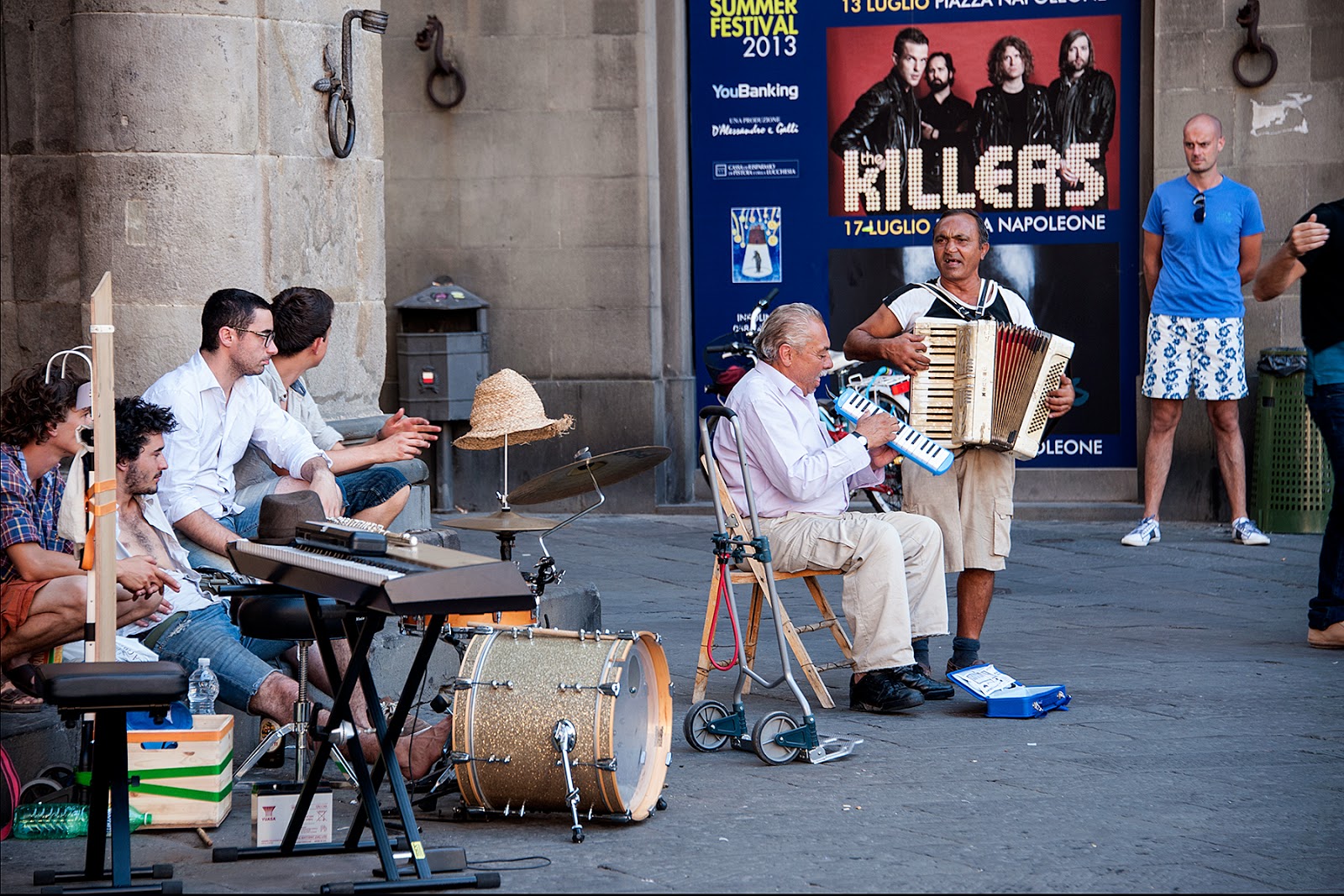
Not Neil Young (or the Killers).


A Lucca summer wedding.  Onlookers point, chant, and dance as the couple emerges.

The girls, dressed to kill and heading out on the town just before ditching their embarrassing grown-up nemeses (me and Ellen).

For you climbers, an anti-stemming device.

A Euro-cat trying to get into one of those Euro-cat calendars, but feeling a little down because he wasn't born in Santorini.

Cathedral sculpture.

Architectural history in brick.

Tuscan weather.

Lucca from one of the many towers in town, none of which are leaning.

A Lucca tower.

The cafe scene at night.

Ellen exploring, just before bedtime.